Approximate Boundary: 39.503974,-79.155296 to 39.457684,-79.226967 (4.85 miles)
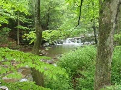
Crabtree Creek is equivalent to Middle Fork as a brook trout fishing destination. It runs wide and clear across a rocky bottom that provides ideal habitat for brook trout. In fact, this is one of the streams identified in the Maryland DNR brook trout management plan as having a robust, self-sustaining brook trout population. Please obey the Zero Creel limit admonishments that the DNR posted at all turnouts! As you drive up Spring Lick Road, the creek presents dramatic scenery that includes deep runs and plunge pools. Avoid fishing near residential areas, even if they are not specifically posted.
Most of the land adjacent to the creek is private property. The Potomac State Forest lies to the south of the creek and includes the land between the mountain and the road for the first 1,400 feet of the stream. At approximately 39.501011,-79.159781, the creek flows through private property with angler access permitted at landowner discretion. As of early 2011, there are no “posted” signs adjacent to the DNR turnoffs quoted above. In addition, DNR signage is at each location, confirming access for now. I urgently request anglers to be gentle with this property and leave no trace to protect future access.
The Potomac State Forest’s northern boundary runs along the old rail bed that rides a precarious ridgeline on the northern side of Backbone Mountain. There is a gap in public ownership starting at 39.480759,-79.185426 , extending to 39.468402,-79.201047. However, according to American Whitewater, aggressive kayakers plop their boats into the creek at the bridge using the railroad right-of-way at the town of Swanton. In the past, they reported friction with one of the landowners in that area. Exercise caution on how you enter the water since the Potomac State Forest property does not begin until 39.457071,-79.221261, approximately 0.3 miles east from the bridge. Any creek that gets kayakers excited based on the number of ledges and drops is usually good for hiking anglers once the water level drops to make the stream uninteresting to those adrenaline junkies.
For those who enter the creek from the Savage River Reservoir side, the best turnoff is 1,000 feet prior to the spot where Spring Lick Road takes an abrupt bend to the north. Do not be tempted to follow the old road that hangs off the ledge to the creek. It is narrow, severely eroded and while you can drive your vehicle down it to reach the edge of the creek, chances are you will find yourself upside down instead of right side up. At this spot, Spring Lick Run slams into Crabtree Creek and creates a set of good pools that will, appropriately, lure you farther west into the deep gorge between the surrounding mountains.
Getting There: From Westernport, take MD 135 west towards Bloomington. Turn right onto Savage River Road. At the first hard, hairpin turn at the west end of the reservoir, take a right onto Spring Lick Road. Crabtree Creek runs on the south side of the road.
Access Point: Various along Spring Lick Road to include 39.49994, -79.16156, 39.49924, -79.16175, 39.49439, -79.16781, 39.49187, -79.17212
Secrets Revealed? No. This is a very public location that is documented in the Eastern Brook Trout Venture initiative as well as in the DNR Brook Trout Management Plan
Tell a friend about this article by clicking on this link


Unless stated otherwise, this article was authored by Steve Moore


