

Approximate Boundary:
·Top Section:39.583726,-77.643729 to39.588241,-77.640269 (2,130 feet)
·Fly Fishing Only Section: 39.583726,-77.643729 to 39.580803,-77.653133 (1.09 miles)
·Middle Section: 39.572246,-77.653869 to 39.578726,-77.655309 (2,641 feet)
·Lower Section: 39.546263,-77.679574 to 39.559106,-77.666399 (2.09 miles)
In addition to offering plenty of put-and-take water, Beaver Creek is one of Maryland’s premier freestone fly fishing destinations as a result of the spring-fed, cold water that supports year-round trout fishing for the biggest “hogs” east of Garrett County and west of the Gunpowder. With plenty of clean, alkaline water bubbling up from the springs adjacent to the Albert Powell Trout Hatchery, water temperature does not limit trout survivability. The stream runs through farmland with minimal drop in elevation – there are no violent rapids or plunge pools to add sparkle and character to the creek. Instead, it meanders adjacent to open fields shaded by thick, tall trees that line both banks. The streambed is a mix of rocks and silt, and the silt is becoming more prevalent farther downstream.
The biggest problem with Beaver Creek is inconsistent public access that requires anglers to be constantly alert for the erection of new “posted” signs.
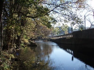
Fishing the top section is straightforward. The put-and-take area starts at the hatchery and runs down to a spot south of the I-70 bridge. Starting at the Beaver Creek Fly Shop, the good channel is initially on the right-hand bank with the deep water flipping to the left bank at the end of the row of houses. When the creek gets underneath the bridge, it widens and shallows. There are no access issues with the put-and-take section as long as you pay careful attention to where you walk and do not stomp on trees or other vegetation planted by the creek-side landowners. As always, it is up to every angler to protect access by being exceptionally respectful to property owners’ rights.
Downstream from the Beaver Creek Fly Shop, the fly fishing only section begins and extends to within 700 feet of Beaver Creek Road. Fishing downstream into the fly fishing only section, there are no property issues until the western bend in the river approximately 50 yards west of the Beaver Creek Church Road parking area (39.586211,-77.648183). The landowner has several “posted” signs dotting the landscape making the section immediately above a small bridge off-limits. From the bridge down to the start of the fly fishing only section, there are no other restrictions as of 2011. The low gradient translates to easy access, walking is effortless.
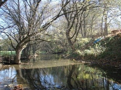
If you choose to park at the southern access point to the fly fishing only section, there is a wide, manicured trail that leads to an open field and the stream. There are plenty of signs to direct you around the private property. Another trail along the creek picks up on the east bank and provides easy walking rapid access to points upstream. One of the most popular spots to fish in this section is the deep pool at the sharp elbowed corner (39.583623,-77.651878). Once beyond the corner, move to the northern bank since there is a steep hillside on the southern bank that prevents passage (39.583176,-77.650103 to 39.584226,-77.646841).
Moving to the middle section below US 40, fishing becomes more difficult, especially for fly anglers. The banks are tall, gradually sloping and tightly hemmed in by packed vegetation. The combination of these characteristics make it difficult for a fly angler to launch an effective backcast. For them, fishing this section requires a well-developed roll cast. Spin anglers will have no problem and there are plenty of deep holes and fallen structure to provide targets. Given the thick vegetation, access to the creek itself is limited to the beaten trails made by generations of anglers that have pushed the vegetation aside. There are a few wide spots that offer salvation. These are obvious and easy to find as you walk along the perimeter of the field next to the stream.
This situation persists until reaching a gradient break marked by a island and a collapsed tree at 39.57303,-77.65394. Note this spot because the creek deepens on the other side. Shortly after, it goes through a sharp turn to dump into the deepest pool in the entire section that also marks the end of public access. On the other side of the pool, “posted” signs appear – ending your downstream hike.
As a side comment, the DNR guidance states that the fishable area in the middle and lower sections include “Beaver Creek Road downstream to the confluence with Antietam Creek (sections of this creek are not accessible to the public).” While this is completely true, it implies that there are miles and miles of fishable creek. Instead, the “middle section” runs a short distance from US 40 and the property is private all the way to the lower section above the town of Benevoia. Below the town, in the lower section, private property reoccurs all the way to the junction with Antietam Creek. In short, there is far more private property between the start point below the I-70 bridge and the junction than there is fishable water. Years ago, the fishable water included everything upstream from Newcomer Road. Not anymore. Given that, each angler must accept responsibility for being alert for “posted” property.
There are only two good access points to the lower section. The one off Roxbury Road has the best parking. The creek is narrow and rocky with a good, deep pool underneath the bridge. Below the bridge, heavily vegetated banks make for a challenging fishing experience. The public section ends at the US 40 bridge (upstream) and at the corner of the field on the downstream side of Roxbury Road.
The other access point is at the Toms Road bridge. The bridge runs over deep water that is a popular holding place for fish and even more popular destination for anglers. During the season, lures, flies and associated strands of monofilament decorate the bridge structure and confirm that this is one of the most heavily pressured sections of Beaver Creek. Above the bridge, the creek narrows with long portions being 6 inches deep. The fish will hold in the scattered locations that offer deeper water.
If you visit Beaver Creek, be sure and stop in at the Beaver Creek Fly Shop on Country Store Road adjacent to the upper section of the stream. In addition to providing great advice on the best flies to use, it is a TFO flagship store as well as a scientific anglers mastery dealer. They carry plenty of gear to include fly tying supplies. For those who are new to the addiction of fly fishing or even those who need a tuneup, the store offers both basic and intermediate fly fishing and tying classes. In fact, the store is unique in that it allows customers to use their fly tying equipment. This is a great way to a worthy you are interested in buying the complete kit.
In addition to being the “go to” experts on Beaver Creek, the store hosts several trips each year to other great fishing destinations on the Great Lakes, North Carolina and Pennsylvania. If you have any questions, feel free to contact the owner, Matt Rosenthal, at matt@beavercreekflyshop.com. The mailing address is 9720 Country Store Lane, Hagerstown, MD 21740.
Getting There:
Top Section:
· Take exit 35 from I-70. Turn south on MD 96 and take the first left onto Black Rock Road. Turn left on Country Store Lane. The parking lot is on the left. Walk between the houses to get to the creek.
Fly Fishing Only Section:
· Option 1: Take exit 35 from I-70. Turn south on MD 96 and take the first left onto Black Rock Road. Turn left on Country Store Lane. The parking lot is on the left. Walk between the houses to get to the creek.
· Option 2: Continue south on Mapleville. Turn right on Beaver Creek Road. Turn right on Beaver Creek Church Road. Go across the bridge and turn left. The parking area is on the right. Go through the gate (please latch) to access the creek.
· Option 3: Instead of turning right on Beaver Creek Church Road, continue. There is a fenced area with a gap. Turn right to enter. Follow the trail (0.5 miles) to the creek. Fish upstream.
Middle Section:
· Option 1: Continue on Beaver Creek Road to the bridge. There is a very small turnout on Cool Hollow Road that will fit two cars.
· Option 2: Follow Cool Hollow Road south to the junction with US 40. Turn east (left) and drive 100 yards. There is a wide shoulder and a gated road on the right. Park and follow the road to the creek.
Lower Section:
· Option 1: From Boonsboro, drive north on US 40 (Old National Pike). North of the town of Benevoia, turn left on Roxbury Road. There is a small turnout on the south side of the bridge
· Option 2: Continue on Old National Pike. Turn right on Toms Road. Make another right when it reaches the intersection. If you go straight, you will be on Lemuel Lane. Follow Toms Road to the bridge and park in the small turnout.
Access Point:
· Top Section: Parking lot on Country Store Lane (39.58294,-77.642764)
· Fly Fishing Only Section: Parking lot on Country Store Lane (39.58294,-77.642764)
· Middle Section: At the bridge on Beaver Creek Road (39.578764,-77.655464) and the shoulder of the road on the south side of US 40 (39.576926,-77.654539)
· Lower Section: Toms Road bridge (39.554784,-77.675167) or Roxbury Road (39.551154,-77.682015)
Secrets Revealed? No. This is a very public location that is documented in the following places:
Maryland DNR
Guide to Maryland Trout Fishing
Tell a friend about this article by clicking on this link

Beaver Creek Fly Shop
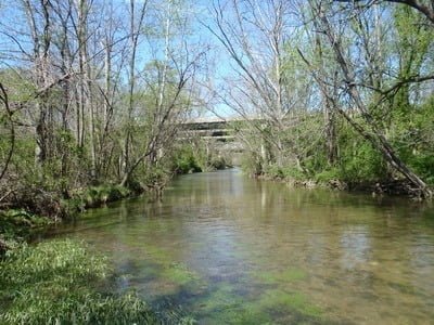
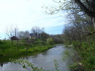
Put and Take Section
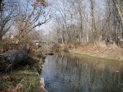
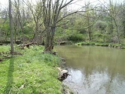
Upper FFO area
Upper FFO area
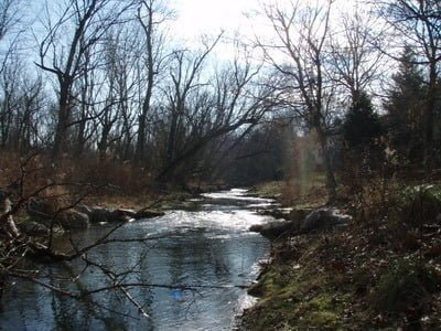
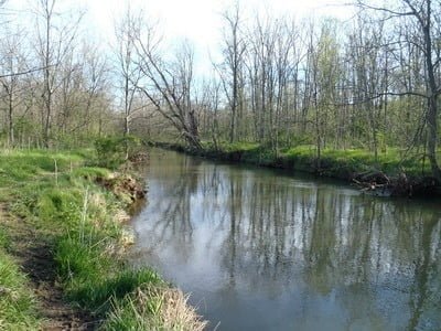
Lower FFO section
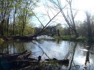
The deep pool at the elbow
One of the wide spots in the middle put and take section
The deep hole at the downstream end of the put and take
The bridge hole off Roxbury Road
Below Roxbury
Unless stated otherwise, this article was authored by Steve Moore