

I had high hopes when I made the two-hour drive on an overcast December morning to Upper Passage Creek. After all, this section had just been stocked. Earlier, I had been disappointed when I fished the put and take area of Passage Creek and was not all that impressed with the delayed harvest area either. Bu it had just been raining for a few days so I was hoping that the combination of fresh trout and higher water would result in a good couple hours on this section.
Upper Passage Creek is miles away from the end of the put-and-take section. It’s at the other end of the valley where Catback Mountain pushes Passage Creek to the west into Crisman Hollow. It’s not hard to find as you can see from the directions below. I was not that concerned when I saw some taillights in the distance as I turned off the hardball onto the dirt road that parallels the creek. However, my concern grew with each passing minute as I saw more and more vehicles. I drove all the way to the end of the stocked area, and there were vehicles at just about every turn-off. It took me a while to realize that most of these guys were not fishing. Many of them had dogs and were clearly engaged in hunting activities. It certainly made me glad that I had my blaze orange hat with me.
On the way back from the distant end, I paid close attention to the creek and the likely turnoffs near the water. Nothing looked like it was deep enough to support fish. If the stock truck inserted any trout in the upper section, they probably throw them into the fast water and hope they are swept downstream into a random deeper spot where they can survive until harvested. As I continued downstream, I saw one other guy fishing off to the left – he did not look very happy. I pulled into a turnoff about a quarter-mile down from him to take a closer look at the water. There were two other trucks parked here but given the hunting focus of most of the people here, that did not bother me as I parked and walked to the creek to check it out. Nothing really compelling. I noticed an old guy sitting in one of the trucks and wandered over to get his take on the situation. Like me, he was amazed that they continue to stock this part of the creek and assured me that the fish get cleaned out rapidly.
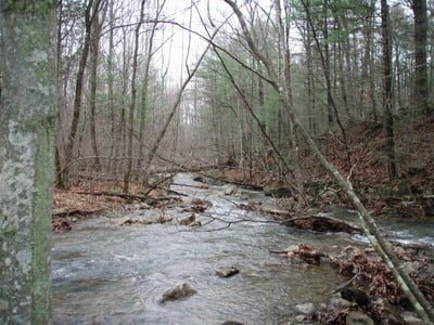
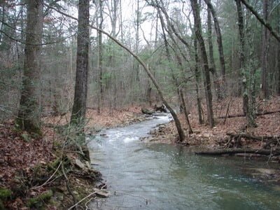
That was not really the news I wanted to hear, as I was on the ground only a few days after the stocking event. So, I continued to drive downstream, looking for any place that had potential. Eventually, I turned into the Lion’s Tale Recreation parking area, which is where the stream flattens out a bit. I hoped the flatter terrain would result in deeper pools where the fish could survive. When I looked at the map of the area (see picture), I noticed that it showed a “wading area”. I hoped that that indicated a wider section and deeper water. I walked the quick quarter-mile down the well improved trail to reach the wading area. As you can see from the pictures below, it is deeper looking upstream, while downstream, the creek picks up velocity as it tumbles over another stretch of moderate gradient. While I was considering what to do, another fly fisherman emerged from the upstream brush.
He indicated that he had had no luck fishing his way upstream. In addition, he told me that he stomped his way back downstream to scare any fish and confirm their existence by being able to see them scatter. Nothing. Given that real-time intelligence, I was not interested in fishing here. We walked back to the truck, chatting about what would be a good next option. I told him that I would head over to either the Rose or the Hughes as both of those rivers had been stocked after Upper Passage Creek.
I hopped back in the truck and began to drive out of the area. On my way out, I took one last look down the steep hill that supports the road for the last half mile of the stocked section. Down deep in the woods, I saw a wide stretch that was marked with several deep looking holes. Now there was a dilemma! Clearly, these were out of range of the stock truck, but they did represent good trout water. Do I schlep down to check it out or do I give up? Given my experience so far, I realized that there was no way I would ever return here, so I decided to give it a shot and hope for the “fish dispersion” factor.

I slipped and slid down the damp, muddy hill and eventually made it to the edge of the creek. I walked upstream and loaded on a nymph with a small dropper and began to work the deeper run where the water entered the beaver pool. As I was doing this, another fishermen popped up out of the upstream thickets and commented that, like me, he had had no luck yet. We discussed how this particular pond would fit into the stock truck calculus which involves proximity to the road versus downstream dispersion. Neither of us had a solution to the equation, so we just continued to fish. I gestured over to the end of the beaver pond and he took up position there and began working that part of the hole. In short order, he actually caught a small trout! I was absolutely stunned given how the morning had been so far and the distance of this particular location from anything. I guess there had been enough rain for the trout to move away from the stocking locations near the road.
With renewed energy, I continued to fish my end of the stream and then walked around to fish downstream another quarter-mile. Unfortunately, that single trout was the only trout I saw on Upper Passage Creek. Resigned to being skunked, I climbed back up the truck and pointed the nose towards the Rose River.
Upper Passage Creek Trout Fishing Bottom line: I wish Virginia would publish how many fish they insert like Maryland does. That bit of information would provide a clear indication of the fishability of a particular stream. I certainly hope they do not put many in this section given the skinny water. If they do, it’s an opportunity I’ll miss and opportunity you’ll miss if you follow my advice not to bother to come here.
Getting There: Google indicated that the fastest way to get here from Northern VA is to follow I66 to I81 south. Take exit 279 towards Edinburg (Rt 185). Stay on Rt 185 east and follow the signs to Kings Crossing – a right turn off of 185 onto Rt 675. Follow 675 until hit turns up the mountain to go to Camp Roosevelt. If you see Camp Roosevelt on your left, you have gone too far. Turn around, go back down the hill and then take your next left to enter the GWNF.
Google Local Coordinates: 38.731255,-78.523836
Secrets Revealed? No. This is a very public location that is documented in the Virginia VDGIF stocking plan for Area 1.
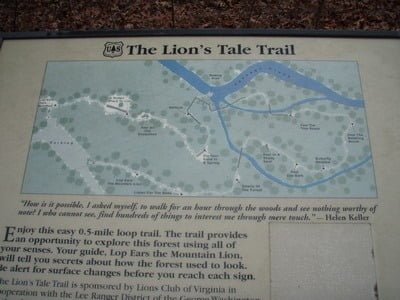
This is the map of the Lion’s Tale area (on the right about a mile in from the intersection).
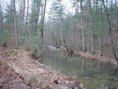
Upstream from the location on the Trail map marked “wading area”
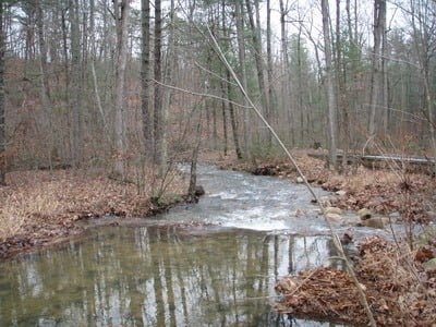
Downstream – it runs into the gorge from here
Looking downstream (east) from the small beaver pond
Upstream from the beaver pond
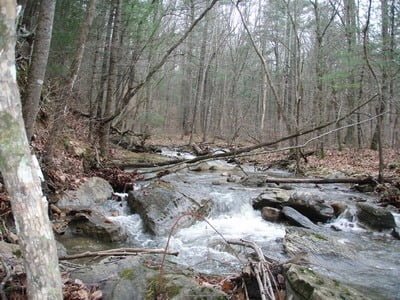
Looking upstream from 1/2 way between the beaver pond and the road
Unless stated otherwise, this article was authored by Steve Moore