After counting over 50 cars and trucks occupying every available turn off in the upstream portion of Passage Creek, I resolved to go to the delayed harvest area and see what it had to offer. Last year, I fished the upstream section and discovered the easy walking path on the right side of the stream that provides easy, quick access all the way up to the dam at the corner. This time, I pointed my rod downstream to see some new territory.
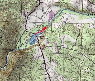
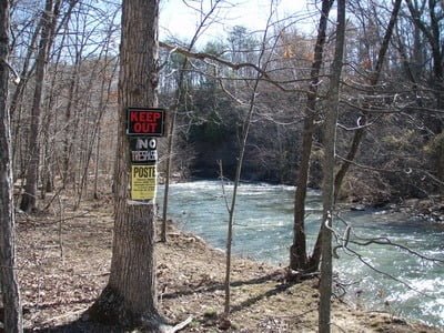
Like upstream on the path, it’s easy walking down the edge of the hatchery property on a grassy, manicured berm that overlooks the stream. Once you go by the first holding tank, continue to the right up the small hill and follow the path down past the hatchery tanks on your right. At the end of the tail races, walk down the short hill to the river at the extreme southern boundary of the hatchery property. You cannot go any further because the stream hits a large, sharp rocky cliff as it makes a hard turn to the left to begin its final push to the Shenandoah.. Unfortunately, the property on the other side of the stream at that point is both private and well marked as such. Even though it closes out, there is plenty of room above the private boundary with good access.
On this sunny March day after all the rain and snow, the water was running high and milky with a definite green tint that cast a pall over the bottom structure and swelled stream; allowing it to claw up the steep banks on either side.. At the northern end of the property, the banks are low and it’s easy to get into the river. Upstream near the parking areas, the opposite condition persists. At the bridge, it is probably a 15 foot drop to the stream bed. This is something to keep in mind if you intend to fish your way from the northern extreme back to your car at the bridge. If you do that, continue under the bridge and you can find a good spot climb out on either side.
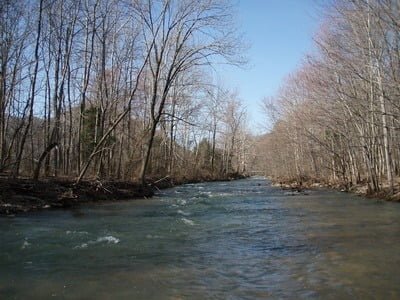
Looking downstream from the bridge, a consistent pattern quickly emerges. The stream changes from tight run to broader pool with each separated by barely visible gradient breaks. Once into the stream bed, you’ll find wading and walking easy although you do need a wading staff. The rocks are not coated with a layer of slime although you should wear cleated boots. The trees and bushes hold back from the edge of the bank a decent distance and that makes it a little bit easier keep your fly out of the surrounding vegetation.
Although it was getting boring to use the same “fly,” I knew I had to rely on a bright pattern to attract the attention of freshly stocked trout. Having been unsuccessful with colored trout magnets farther upstream, I fell back on a bright gold Patuxent special and cast it upstream in a quartering fashion . Twitching gently and hauling quickly to keep up with the fast-paced current, I repeated this a number of times until I was finally rewarded with a decent sized stocked trout. I waded upstream and cursed softly to myself as I saw dark forms skitter in front of me and head to the sides of the 30 foot wide stream. Spooking the fish!
Date Fished: 3/20/2010

At high water, you don’t get a break – it’s a challenge to keep the lure moving properly as well as just maintaining a foothold in the intense flow. The high condition complicated the fishermen’s calculus of identifying likely holding positions near boulders and seams. The boulders were all covered and the seam disappeared as it blended into the overall current.
Passage Creek Trout Fishing Bottom Line: Although Passage Creek is a very scenic section of water, the put and take section of the stream gets intense pressure given the proximity of the numerous parking areas and campsites to the creek itself. As long as it was not stocked at the same time, the delayed harvest area is a little calmer and is a good alternative when the upstream section has been freshly stocked.
Getting There: From Front Royal, go west on Rt 55. Turn left onto Fort Valley Road (Rt 678). Follow it for a bit and turn left on Rt 619. There is a sign at the intersection of 678 and 619 that directs you to the hatchery. Follow 619 until you cross Passage Creek. Pull of on the hatchery side of the bridge. There is parking on the side of the road on both sides.
Google Local Coordinates: 38.948903,-78.296428
Secrets Revealed? No. This is a very public location that is documented in the following places:
Virginia VDGIF
Flyfisher’s Guide to Virginia
Tell a friend about this article by clicking on this link

Upstream – you can see the bridge at the parking area in the distance

Downstream towards the bend

Private property on the west side is well marked

View from the extreme northern part of the hatchery property
Unless stated otherwise, this article was authored by Steve Moore


