So, what are the pros saying about the Dan River above the Powerhouse?
Harry Murray asserts: “From the Pinnacles Hydroelectric Power Plant upstream to Townes Dam there is about 3 miles of excellent water with a good population of reproducing brown trout. The further up the section of the stream you fish, the better the action is.”
Harry Sloan elaborates: “Behind the two-story brick hydroelectric facility down below lies that half of the Dan River not captured by the underground flume, following the original streambed. In this unlikely setting is one of the more spectacular trout waters in Southwest Virginia, with classic falls and deeps, containing green water occasionally disappearing into the black holes tunneled out by centuries of fast water.”
The copyright on Sloan’s book is 1991, and Murray’s book was published in 2000. Over the last 8 to 10 years, bad things must’ve happened to the Dan River above the Powerhouse. I had an inkling of what was to come when I spoke with another fisherman who showed up at the publicly accessible outdoor bathroom at the Powerhouse as I was gearing up to begin my hike. He commented that he and his buddies had not had a good day the day prior and were denied a meal of brown trout for supper. It should be a red flag to anyone when you hear another fisherman stringing together comments about dinner with a reference to wild trout water.
First, the details. You need a special permit to fish upstream of the Powerhouse. These can be obtained from the city of Danville or at the power plant itself. I was concerned about risking the long drive to the Powerhouse without guaranteeing a pass, so I spent time trying to find a number to call in Danville. Unfortunately, I could not find a direct number to anyone in Danville who would be willing to fax me a permit. It turns out that my fears were ungrounded. The Powerhouse is manned, and they are happy to issue permits up until 7 PM in the evening. The sign on the door did not have a minimum “show up” time in the morning, so I assume you could even get there at 6 AM and obtain a pass. To get the pass, go through the door and up the stairs to the control room.
It’s an impressive little facility! I chatted with the operator, and he told me that the generators date from the late 1930s and are still humming right along; popping out juice as if they were just installed. The operator cautioned me that there were bears, mountain lions, rattlesnakes, and copperheads upstream. Of course, there are two ways to take this. One is at face value as a disclaimer that goes along with permission to access the property, and the other is to discourage fishing traffic to protect the natural environment. In this case, I’m sure it was a little of both. I mentioned that I had my canister of bear spray with me and received an affirmative grunt that I would probably be okay.
Outside, I ran into the aforementioned other fisherman, and he, too, repeated warnings of snakes and various wild animals upstream. I was beginning to feel that there was a campaign to discourage traffic up the river. With a shrug, I thanked him for his advice and began my walk upstream. I decided to put 1/2 mile between the Powerhouse and where I would begin based on the admonition in the book that the fishing would be better the farther you penetrate into the wilderness. The initial part of the trail is broad and well maintained; it looks like someone runs a lawn tractor up it; it’s an easy walk. At the half mile point, the trail broadens out into a clearing and I could see a smaller, fainter trail leading down to the river. As the left fork in the trail started to veer uphill along the side of the mountain, I decided it would be better to get into the river and work upstream where I could fish and see the water.
As I left the trail, it was as if a door shut behind me. The sounds became muffled, the lights dimmed, and the trees closed in around me. Down below, I could hear the distinct noise of water crashing across rocks and that quickened my steps as I was anxious to begin fishing. When the trail opened up onto the river, I was startled to see how small it was. It was no bigger or better than the Rose River in the Shenandoah. In fact, if you had blindfolded me and dropped me into this setting, I would’ve sworn I was in the Blue Ridge on one of the small park streams. The river was no more than 10 to 15 feet across, running shallow as it dodged around rocks and boulders spilling down the mountain from pool to pool. “This will be okay”, I thought to myself as I looked at the pools that I could see in front of me. I assumed that I would have good pocket water fishing upstream.
Sadly, the pockets were as shallow as they were frequent. It was a rare pool that exceeded 1 foot in depth. The runouts from the pools averaged about 6 inches with the deepest parts tucked under the rocks where the water spilled into the pool. Since I was here and had invested a long drive and a decent hike, I decided to see if it got better farther up — after all, that’s what was promised in the two guidebooks. I tied on an ant and began to work my way upstream.
In every pool, I experienced a chattering attack on that little ant. These pools are full of very small trout. They are so small that they could not get their mouths around the size 18 ant that I was using. I did not want to go smaller because I did not want to actually hook anything that wasn’t going to be interesting. Why hurt a little fish when what you’re looking for is the older brothers and sisters? The water was crystal clear and when I finished fishing each pool I would walk to the side and peer to the bottom. I did not see the skittering, scattering of larger forms dashing out of the way upon my approach. Instead, just the little guys running for cover.
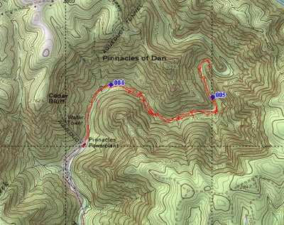
Waypoint 004 is where I entered the stream. Waypoint 005 is where the beaver pond is.
Where were all these 12 to 14 inch native brown trout the guidebooks discussed? The largest fish I caught is in the pictures below. Not much of a payoff for exceptionally challenging hike.
I continued upstream for a good 2 miles. 1.25 miles out from the powerhouse, you encounter a lake formed by a beaver dam. Here, the water does get deep — three or 4 feet in sections. The bathroom fisherman mentioned this as a good spot. so I spent an hour working around the edges without any luck, any hit, nothing at all. I began to wonder if this is where he and his friends had caught the brown trout he mentioned that they had eaten for dinner two days ago. There were the little guys chittering and chattering at the terrestrial patterns that I threw, but nothing else. No interest in streamers either. Above the beaver dam, the water got a little bit better with the pools being slightly deeper than down below. The river widened out to 20 feet in the section and the deepest portions of the pools probably approached 2 feet. Unfortunately, my lack of luck coupled with my lack of skill resulted in a long nature hike with no satisfying, adrenaline pumping excitement.
Finally, I turned and began my descent back to the Powerhouse. It’s always a lot easier and faster to move when you’re not trying to be stealthy and quiet. It did not take long at all before I was back on the trail walking to the powerhouse. On the way back, I looked down the sharp, steep incline to the river and was startled to see that it appeared to be deeper in this section than it was upstream. I could see some larger waterfalls and deeper pools which led me to the conclusion that perhaps the best part of this water is in the half mile right above the Powerhouse; the parts that I had skipped and did not have the time to investigate further. When I got back to the powerhouse, there were two other fly fishermen who were just about to start walking upstream. I relayed when I had encountered to them and gave them the advice to start fishing immediately upstream of the Powerhouse to see if that was a better stretch of water because I can guarantee that the two-mile section that I had fished would not be productive at all.
Dan River Trout Fishing Bottom line: This was definitely not worth the 307-mile drive from Northern Virginia. Something tragic must’ve happened between when the books were written and when I arrived. Maybe it was the drought of a couple summers ago or maybe it was pressure from folks who don’t abide by catch and release fishing for native trout. Who knows? While this section is spectacularly beautiful, it certainly is not worth the hike. So, unless you’re more into hiking then fishing, I recommend you go someplace else. It is still on my list to visit the upper part of the Dan River that is only accessible by canoe. I did not have my canoe with me on this trip, that will be a goal for next summer.
Of course, my experience could just be chalked up to lack of skill and maybe there are nice browns here….
Getting There: The directions in the Flyfisher’s Guide are wrong. Find Claudeville on the map and turn north onto VA 773 off VA 103. Turn right onto Kibler Valley Road (VA 648) and follow it all the way to the Powerhouse.
The VDGIF stocks the Dan River below the powerhouse, so you can fish that as well.
Google Local Coordinates: 36.666422,-80.447903
Secrets Revealed? No. This is a very public location that is documented in the following places:
Virginia VDGIF
Flyfisher’s Guide to Virginia
Virginia Trout Streams
Virginia Blue-Ribbon Streams

Trail leading upstream from the Powerhouse
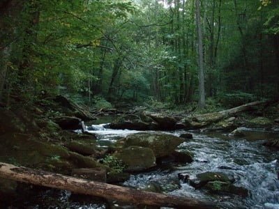
Upstream from entry point
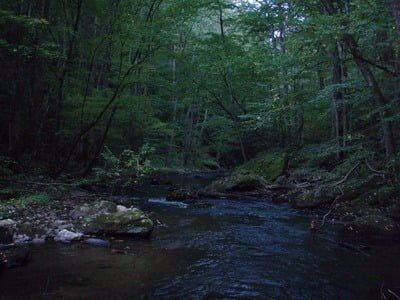
Downstream from entry point

Typical pool
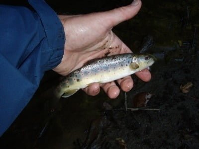
The biggest and only fish of the day
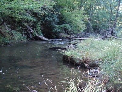
One of the deeper pools

Beaver pond looking upstream

Beaver pond looking downstream

It does not get more scenic than this!

Unless stated otherwise, this article was authored by Steve Moore
