

Last week, we had unusually warm weather at the end of December, which prompted me to get outdoors. I had never been to Paddy Run and knew it had been stocked in early December. That was enough motivation to drive out there to look at it and maybe even catch a fish. I had read about Paddy Run on several different forums, and, of course, it is fully disclosed in the Virginia stocking plan. Even with that, I really did not know what to expect — in my mind, I had a vision of a Maryland creek like Great Seneca, which did not offer much in terms of structure or scenery. Thankfully, Paddy Run is the opposite.
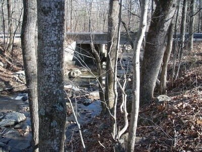
I pulled off the main road in the first parking lot where the “trout stocked water” signs began just north of Route 600. I exited the truck and looked up and down the stream. There did not appear to be much water here, so I wrote it off in terms of fishing on this particular day. I noted that a dirt road paralleled the west bank of the creek and assumed that it provided access for the stocking truck, but I did not follow it to see how far up it went. Instead, I followed the major dirt road up to the northern access point, which was about a half-mile upstream.
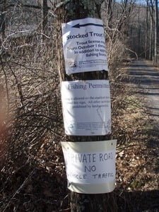
As you can see from the picture below, there is plenty of posted documentation about this stretch of the creek. It’s obvious that Paddy Run is mostly on private property, and our access is controlled by the kindness of the landowners whose property the stream runs through. I respected the sign prohibiting vehicles and walked to the stream from the intersection. The red line on the map shows the total extent of my hike and represents a 3.27-mile round-trip. Of that, only a quarter mile each way was spent walking from the parking area to the actual stream. Given that short distance, I hope folks respect the landowners’ request and do not drive farther in.
The dirt road runs all the way up to the top of the redline, where it begins to move away from the creek. VDGIF posted the “stocked trout water” signs regularly along the entire stretch. About a mile and a quarter in, you’ll run into a gate that prevents any vehicle access, whether it’s a landowner or a trespasser, from moving farther upstream. The stocked water signs continue, so I assume the stock truck has the key to continue upstream.
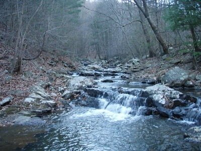
Walking up the road will drive you crazy as you look at the water. If Paddy Run were over on the other side of the valley in the Shenandoah National Park, this would be considered “big water.” The stream is typically 15 to 20 feet wide, with a bottom that is covered with rocks and no sand at all. In addition, there are plenty of boulders and flat ledges to provide the eye candy that a hard-core trout fisherman looks for. While there are some shallow riffles between the major drops in elevation, I had the impression that the stream was mostly one small pool tailing into the next small pool. There is evidence of pressure at the larger pools in that you can see a beaten trail from the road leading down to the creek. Other than that, there is no trash — people seem to take care of this stream.
On the day I was here, I walked directly to the end to do a full visual recon of the water and then began fishing my way back. It was late in the afternoon, so I only stopped at two or three places to flip my fly. I tried a green weenie and a small stonefly pattern with no results.

Late in the day, I noticed a few small bugs flitting around, so I attempted to match those with a size 20 BWO pattern. But, as the shadows deepened in the canyon, I’m not sure that the fly was visible to any fish. In addition to the stocked trout that are put in here, I bet that there is a brook trout population that lives here year-round. When you look at the course of the stream and the dense overhanging vegetation that protects it, my assumption is that the water can stay cool – particularly if it is fed by a few spring creeks and seeps.
Paddy Run Trout Fishing Bottom Line: Paddy Run is place is definitely a keeper that I will return to in the spring after it is reloaded with fish. It looks like a good alternative to Passage Creek and some of the other east slope of the Blue Ridge streams like the Hughes and the Rose which get a significant amount of pressure based on their proximity to the Washington Metropolitan area.
One final point is that the stream south of Route 600 is all private property and posted — so when you visit Paddy, be sure you fish upstream.
Getting There: From I81, take exit 296 onto VA 55 to Strasburg. Turn left onto Star Tannery Road (604) on the other side of the ridge. It will change to Gravel Springs Road and then to Oates Road.
When it changes to Oates, it also becomes Rt 600. Continue on 600 to Paddy Run. It is a medium sized bridge and it will be obvious. On Google, it shows the bridge at the intersection of 600 and 601 (Paddy Cove Ln). I do not remember seeing any road signs here, but I was not looking.
Note: Since going, I was told there is easier access from the top. I’ll check that out on my next visit.
Google Local Coordinates: 39.045386,-78.482208
Secrets Revealed? No. This is a very public location that is documented in the Virginia VDGIF stocking plan

Looking north from the bridge parking lot
South back to the bridge – you can see it is “large”
This is the set of signs that marks where you should park

This pretty scene is where the stream meets the road after you walk in
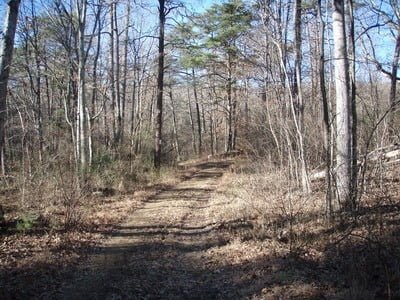
Wide road runs all the way up the river

Stair step section

You can see the gradient here

Nice small waterfalls break the water
Looking upstream from the middle
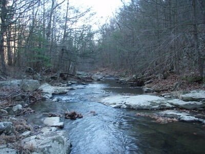
Nice pools merge into each other
Unless stated otherwise, this article was authored by Steve Moore