


The first time I came to Piney Run, I was confused about what was public and what was private. Based on that lack of certainty, I deferred to fishing the Piney until I could get guidance from someone who had been here before. Now, armed with that guidance, I rolled into a stop at one of a few parking places at the base of the trailhead in mid-June.
I parked next to the rock wall and, since the homeowner was in the yard, I confirmed with him that it was okay to park there. We had a short chat about fishing on the Piney and he recommended that I walk a full 2 miles before starting to fish. I thanked him for the intel and permission, geared up and headed up the driveway that had confused me before. The drive has a sign posted on the tree to the left that prohibits driving farther up the road. On my last visit, I misinterpreted the sign to mean that foot traffic was not allowed either. That’s not the case and you can walk up the driveway to reach the trailhead. Eventually you come to a gate that is clearly marked with no trespassing signs with a forest service concrete post on the left-hand side.
The Piney trail arrow embedded in the metal plate on the post points across the river where you can see a skinny trail leading up the opposite bank. It eventually joins a dirt road, that is another driveway, and leads farther into the forest. As you walk up the driveway, you pass numerous posted signs on the right — do not start fishing until you see the forest service sign three quarters of a mile from the trailhead. You can’t miss it. At that point, the road takes a hard left and the sign is next to the river. On the other side of the river, the trail continues into the woods. The landowner has provided additional clarity on what is public versus private by heavily posting the property on the left-hand river bank.
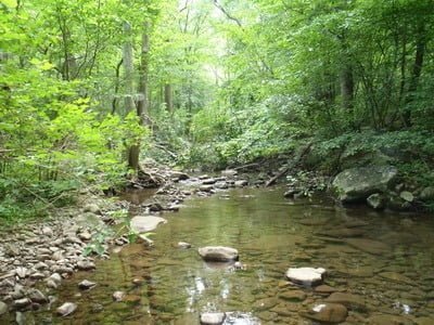
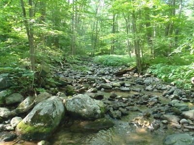
After you cross a river, you walk up a short 15 foot hill to discover the formal entrance into the park that is denoted by a chain stretched across a trail and a totally unnecessary “no parking” sign. The trail continues up the right bank of the river; moving away after a short distance. Although you can hear the river off to the left and catch glimpses of it through the trees, you have to walk 1.51 miles and endure 242 feet of vertical gain before it crosses the river again. Frankly, I was disappointed in what I had seen so far. The stream was a small trickle of water that dribbles across a boulder strewn river bottom that is cradled between banks that are 15 to 20 feet apart. I had seen randomly dispersed small pools, but nothing as pretty or interesting as exists on the major trout rivers that hang off of the Blue Ridge farther south.
Based on the guidance of the landowner, I decided to continue walking upstream because he said that the good fishing started a full 2 miles from the trailhead. It turns out that the trail crosses the creek again at 2 miles. In early June, with the temperature hitting 90°, it was a very sweaty walk to reach this point. The Piney was looking pretty dry and left me wondering whether my definition of “good” was the same as the property owner’s. At 2 miles, I knew I was at the start point of what should be a good water. I resolved to walk a little farther upstream to see if the terrain pitched up to create the plunge pools I was looking for. Immediately prior to reaching the stream at mile 2, you encounter another concrete post that gives you additional options on trails. The arrows for the Piney Branch trail pointed both up the hill on the left and across the river. Given those two choices, I decided to head in the direction of the river; hoping the trail would say closer to the water and I could assess where I wanted to stop walking and start fishing by keeping an eye on the water.
2.3 miles from the truck, the trail crossed the stream again and I decided that I should start fishing here. I passed a hiker walking back to the trailhead and he had said the river becomes spectacular beyond a turn marked with a small rise. As I stood at the crossing, I could see a hump to my right front and resolved that this was the rise — besides, I was fed up of hiking and wanted to start fishing. With that, I knelt down at the edge of the stream to scrub the insect repellent and suntan lotion off my hands before I rigged up my first fly. And what to start with? Naturally, Mr. Rapidan.

I began walking up the stream bed; fishing the exceptionally small pools that collected at the base of rocks. As I continued to walk up the river, I became more and more disappointed with what lay in front of me. While there was plenty of water in the river, it was broadly distributed across the wide stream bed; causing it to run shallow. This prevented the water from pooling to provide good holding areas for larger fish. While the small 1 or 2 foot pools that ranged from 6 inches to 1 foot in depth all held small trout that were anxious to snap at the Mr. Rapidan, there was nothing really exciting about fishing any of them.
When I hit the stream crossing at mile 3, I realized I had three full miles to walk to get back to my truck. At that point, I decided that the Piney was a river to explore earlier in the season when it might hold more water and provide better locations for the larger fish to come out of hiding. I have no idea where anything big would hold over the summer and water this small.
Piney River Trout Fishing Bottom Line: I think I’ll pass on the upper Piney in the future since the river fails to provide plunge pools or deeper holding areas for fish. I have to conclude, after walking 3 miles, that it just is not worth the energy to go significantly upstream beyond the entrance (3.05 miles / 452 feet of vertical). On the way back down, I periodically walked from the trail back over to the river to see if I had made a bad choice by making a beeline 3 miles upstream. The sad truth of the matter is that I did. The first 2 miles up from the trailhead appear to be the best.
Although, immediately upstream of the entrance to the park, the river becomes schizophrenic and runs in multiple channels, above that section it stabilizes and fills its bed with plenty of water spread across decent sized pools.In fact, everytime I cut back over to the river, I found myself looking at much better water than I had stumbled across 3 miles upstream. Therefore, on my next trip, I’ll go through the gate, walk above the multiple channel section, and then cut to the river and begin fishing. there’s plenty of good water in this stretch and, in the few pools that I had time to fish on the way back to the truck, I was successful in pulling out 5 to 6 inch fish. I’m sure there may be a few larger fish this in this water ….although it is skinny.
Getting There: From Warrenton, head west on US211/522. Turn right onto Rt 612 prior to entering Sperryville. Do not take the turn where Rt 612 takes a hard left at a road junction. Continue straight ahead on Rt 600. Follow it until it takes a hard left next to a stone wall. If you continue to the left, you will go across the river and pass a locked gate on the right. Park wherever it looks legal – the stone wall seems to be an OK place. Walk up the drive that leads directly north from the stone wall (do not walk up the driveway that runs perpendicular to the wall. The trailhead is well marked.
Google Local Coordinates: 38.69442,-78.25824
Secrets Revealed? No. This is a very public location that is documented in the following places:
Virginia VDGIF
Flyfisher’s Guide to Virginia
Tell a friend about this article by clicking on this link
Date Fished: 6/9/2010

Entrance to the park
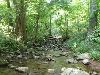
Upstream from stream crossing at the entrance
View from the trail
Upstream – 2nd crossing
Upstream – third crossing

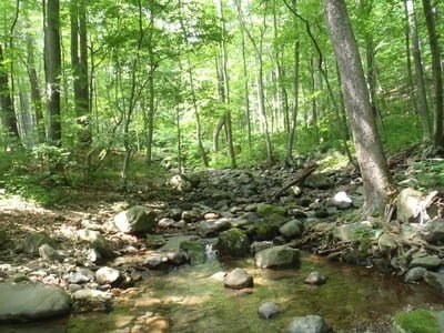
Wide stream bed, not much water

The farther up you go, the skinnier the water
Upstream at mile 3
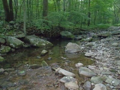
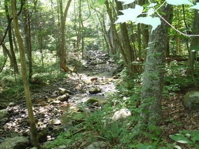
Example pool in the 1st mile
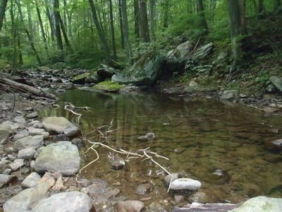
Another 1st mile… better to fish this section.
Unless stated otherwise, this article was authored by Steve Moore