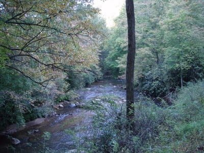
Since I was here, I decided to take a quick run down Crooked Creek to see what the rest of the fee fishing area looked like. I had spent an hour or so in the middle of the fee fishing area near the huge parking lot and had gone to the upper end of the East Fork in search of wild trout later in the day. This would be my last look at this water and I was more impressed with what I found here than at either of the other two locations.
The fee fishing area of Crooked Creek runs from the 620 bridge I discussed in this post all the way down to the intersection of 620 with route 713. There are several houses scattered along this section — mostly on the left — but there is a cluster overlooking the creek at the far lower end. As a result, private, posted areas are interspersed with the turnoffs that provide access to the fee stretch. The existing turnoffs also serve as good positions for the stock truck as they load up the stream daily during the season. Unlike the middle section, there are no widespread, large parking areas. Assuming the large parking lot portends huge crowds, just getting here early and parking in one of the small turnoffs or walking downstream from the big parking lot will probably improve your fishing experience. I bet that during the season, the crowd diminishes in direct proportion to the distance from the large parking lot.
The character changes as the creek rounds the corner formed by the large ridge poking south. The water hits a higher gradient, which pushes it downstream a bit faster than in the other sections. In addition to trouty-looking rocks, which compress and speed the flow, there are some large, broad pools that are probably prime targets for fish insertion. I noticed that in 2008, they alternated stocking between the lower and upper ends of Crooked Creek day by day. If they continue this into 2009, you should confirm where the daily dump occurred to ensure that you are fishing where there is a higher density of trout.
Crooked Creek Trout Fishing Bottom line: If I had to choose the water to fish in the fee fishing area, I would choose this section. Its limited parking, better-looking water, and potential for less pressure with an equal share of the fish distributed daily during the fee season make it the logical choice.

Getting There: Take exit 14 from I77 west on 221 towards Galax. Turn left on 620 (south) and follow it all the way to the fee fishing area. Get your pass in the concession area at the south end of the parking lot and continue down the road. Fish anywhere you can legally park.
Google Local Coordinates: 36.675923,-80.812597
Secrets Revealed? No. This is a public location that is documented in the following places:
Virginia VDGIF
Flyfisher’s Guide to Virginia
Date Fished: 10/4/2008

Looking upstream from one of the turnoffs

Broad pool – steps away from the road
Unless stated otherwise, this article was authored by Steve Moore


