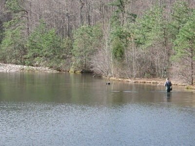
The Virginia Game and Inland Fisheries trout stocking plan mentions that Coles Reservoir as one of their stocked locations. Since I was in the area, I decided to take a quick walk up the road to see what it had to offer. The access is off Coal Road, which is a dirt road that is easily accessible by normal flatland vehicles. Follow it from the intersection noted below until you see the gated entrance to Coles Reservoir on your right. There is no sign there, you have to look for and be aware of where it is on the map.
Pull into the one car parking area at the entrance, gear up and walk up to the reservoir. If there is already a car parked at the gate, there is an alternative parking area in the small campsite to the east of the entrance as well as additional parking across the road. You may be tempted to fish the stream that pours out of the base of the reservoir, but in the summer that flow declines to a dribble; making it less than interesting.
Instead, head south on the road up the gentle slope to reach the reservoir itself. After walking up the easy 281 foot rise to the lip of the reservoir, walk to the left to check out the spillway. Sadly, most of the runoff from the reservoir goes over the top instead of being a true tailwater. However, there is a exit tunnel at the base, but it looks like it drains water from the top of the lake instead of the bottom. I suspect that it is all from the top and that there is no hope of making this a cold water trout fishery.
As you look across the expanse of the lake, you will be grateful that you brought your spin rod instead of fly gear. The lake is deep and heavily forested on both banks. The access road transitions into a small fisherman’s trail on the west side of the lake. The trail runs from the lip of the dam all the way up to the creek that spills into the southern end of the reservoir and keeps a full. Whereas the northern end is deep, the southern end is shallow. A 25 to 35 yard gentle lip extends from the base of the stream out into the lake.
Wade out on the sandy bottom and fling your spinner or crank bait as far into the lake as you can. There’s a small sandy campsite at this end of the lake that looks like it has been well used. If the stream looks good, you can either walk up the streambed or you can get back on the faint trail leading south from the campsite that parallels the creek for a moderate distance.

If you bring a fly rod, bring a short stick as the feeder creek is overgrown and densely forested for the short distance I walked up it. I did not do a full recon of the feeder creek and the conditions may improve the farther south (upstream) you go. I suspect that it was will close in once the leaves grow on the thick bushes that line both sides of the creek. Although I did not fish up the creek, given the fact that there is a reservoir here, my assumption is that there is a robust flow year-round to keep the reservoir full. That implies that for those who are willing to walk farther upstream, you might find some pretty good brook trout water.
The distance from the gate to the end of the lake is approximately 3/4 of a mile so it’s not that strenuous of a trout hike.
Coles Run Reservoir Trout Fishing Bottom line: This is not a bad diversion if you are fishing other water in this area. Even though the campsite at the southern end of the lake was full of trash, I did not get the sense that this water is heavily pressured. I only saw one random bait container and a few beer cans — not bad for America today.
Getting There: From I64 westbound, take exit 84 onto US 340 towards Stuarts Draft. Turn left onto Route 608 (it turns into Route 610) it joins Route 660. Turn right onto Route 660 (Lake Road) and follow until it intersects Coal Road. Turn left onto Coal Road and follow it to the gated road leading to the Reservoir (approx 0.4 miles)
Google Local Coordinates: 37.976003,-79.03013
Secrets Revealed? No. This is a very public location that is documented in the Virginia VDGIF stocking plan.
Tell a friend about this article by clicking on this link

View south from the lip of the dam

View north from the creek junction

Feeder stream looks good and merits investigation

Upper end is wadeable.
Unless stated otherwise, this article was authored by Steve Moore


