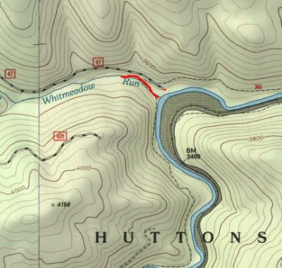
After fishing upstream from Forest Road 47, I returned to the truck and noticed a strong stream of water pouring into the Cheat right next to the parking lot. A quick look at the map revealed that the small stream had a name, Whitemeadow Run. Although the weather was quickly getting colder, I wandered upstream to see if there were any good plunge pools and perhaps pick up a brookie or two.
This water is tight and close! The rhododendrons cling tightly to the water’s surface and provide cover that prevents anyone but an expert caster from getting a fly on the water. I had seen this before in other mountain streams and was hopeful that as I continued to push ahead, I would find the pristine pool filled with plenty of nice trout. As I bushwhacked my way up the stream, a huge object moved in the water ahead. There was a huge trout swimming back and forth in water that was no more than 6 inches deep. Since the only reason it would be this far up such a small stream was to spawn, I watched it and then moved on. After seeing this fish, I realized it was too late in the season to try and catch anything, so I disassembled my rod and continued to walk upstream to scout for a future visit.
Although I could see small trout skittering around in the shallow pools as I approached, none of the pools except for one, were unobstructed enough to provide an opportunity to fish. The thick trees, the thick bushes, and the rare deep spot that held the fish were few and far between. I noticed that there was an improved trail and ran next to the stream marked with blue blazes on the trees. I followed that up as far as I had energy; periodically diverting back to the stream when the trail veered away. Each time I returned, the terrain remained unchanged. Tight thick bushes continued to hug the surface with good numbers of tantalizing small trout skittering around; taunting me about my inability to deliver a fly to them.
Whitemeadow Run Trout Fishing Bottom Line: This is certainly unfishable for me. A hard-core mountain angler might find some joy here as there are certainly plenty of fish, with the number of fish increasing in the more difficult spots.

Getting There: Locate the town of Durbin, WV. Head north on US 250 and be alert for the bridge over the Cheat River. About 3 miles from the bridge, turn right onto PR 92. It runs up a ridge and the access points to all of the Shavers Fork spots are turns to the right from this road. Follow the road until you see the sign for FR47 and follow it to the river.
Google Local Coordinates: 38.663196,-79.86331
Date Fished: 10/14/2009
Secrets Revealed? No. This is a very public location that is documented in the following places:
Flyfisher’s Guide to Virginia
Mid-Atlantic Budget Angler
Tell a friend about this article by clicking on this link

Tight

Tighter

Impossible

The only pool easily fishable
Unless stated otherwise, this article was authored by Steve Moore


