On my way back from fishing on the South Branch, I left time to check out some streams marked as stocked water on the WV Trout Map. The map is a great asset in the truck with you since it allows you to change your plans and reorient your fishing as needed.
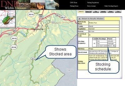
The WV DNR does have a comprehensive online mapping application that shows a detailed map of the stocked area and the stocking schedule. When you are connected, you can use this application.
Here is what they show for Waites Run:

The first thing that jumped out at me was. “Where are the signs marking the stocked water?” The road winds along a pathetic-looking stream dotted with homes on both sides until you enter the national forest. I called the Elkins DNR station after getting home and was told that WV does not mark stocked water like MD and VA do. You must know where it is and pay attention to “posted” signs. Well, that is not good, and that is another reason to bring a reference guide with you.
Waites Run is a nondescript body of water that does not merit a special trip. In March, even after a good dose of spring rains, the water was a trickle. I was amazed to see that the WV DNR stocks this creek once a week between March and May. Kudos to WV for having such a robust stocking program. You have to wonder where they dump those fish or how many they plant in this small body of water.
Obviously, every stream/road crossing is a potential stocking point assuming there is enough water to float a goldfish.
At waypoint 032 on the map, I was pleased to see a small sign on the road welcoming anglers and cautioning them to park on the road before walking to the stream. I did and walked down the 25-yard driveway to the stream crossing. Small water limping down a gentle gradient bordering several homes – I could imagine fish being stocked here and instantly snaked out given the insignificant amount of water.
I continued south on Waites Run Road and peered intently at the stream as I drove. I stopped at each stream crossing to take a closer look… with itchy casting hand at the ready… only to discover nothing worth fishing. The scenery improved once into the national forest upstream from waypoint 033 on the map.

However, even here, “posted” signs popped up intermittently along the road. At the top of Waites Run, there is a large pull off that leads to a nice section of the stream. Although I did not bother to fish it, it may be OK parking here and then working downstream. Upstream just takes you onto private property.
Date Fished: 03/23/2009
Waites Run Trout Fishing Bottom Line: Not worth the drive unless the water levels are up (like right now 5/10/09) since WV does dump fish in here weekly during the season; I bet they tailor the stocking amount to what the water will support. But, there are better places to go if you are willing to drive a bit farther into WV. Hats off to their tourism folks for being so aggressive in attracting out of state fishers by stocking every wet spot in the state!
Another key point is that you should not fish in WV unless:
- You know where you are going and where it is legal.
or
- You have looked up the water on the online application and print the boundaries
or
- You have the WV Trout Map with you… but need to recognize it may be out of date and exercise care.
Getting There: From the WV Website: “From I-81 at Strasburg, Virginia take Exit 296 (State Route 55). Follow State Route 55 towards the West Virginia state line. From the West Virginia state line travel about 6 miles to County Route 5 in town of Wardensville. Turn left (East) onto County Route 5 and follow about 1 mile to bridge over Waites Run.”
Google Local Coordinates: 39.060749,-78.584304
Secrets Revealed? No. This is a very public location that is documented on the WV Trout Map.

Typical view from a stream crossing

Guess this gets a few more fish as it is deeper. There is a large turnout to the left of the is picture.

Scenery gets better in the national forest.

But… the water stays pretty skinny
Unless stated otherwise, this article was authored by Steve Moore


