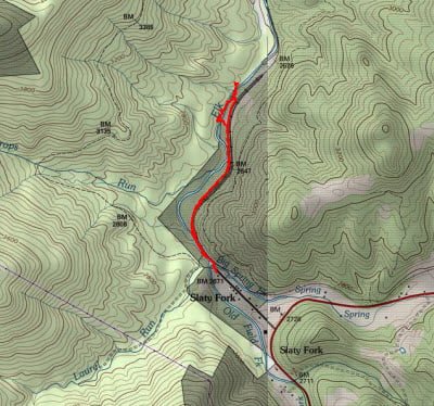
After all, I have heard about the Elk River in the last several years, I was excited to point the truck at the Slaty Fork section. If you look closely at the map, you’ll see a small stream labeled with the same name that feeds into the actual Elk River. This is not the place you go to fish. Rather, the Slaty Fork is actually named for the town that hosts the parking area. Out of curiosity, I confirmed this by driving by and taking a quick look at the actual stream — the streambed was totally dry, and the optimist landowner had plastered “posted” signs around the logical parking areas — clearly, this was not my destination.
Following the ample, accurate instructions from the West Virginia DNR, I turned off the main road. I drove through what looked like a lumberyard/lumber factory to the end of the road, where it transitioned from hardball to dirt and eventually led over a steep berm marked with a “no camping” sign. I was slightly confused as I had expected to see something more definitive marking the start of this particular section. I slowly drove the truck over the berm and was relieved to see a sign that announced that I had arrived in the Slaty Fork section.
I geared up and walked down the trail that joined with an old, rusted rail bed stretching into the distance. After seeing the well-maintained railway up by the North Branch of the Potomac, it was interesting to see what happens to a rail bed as it falls into disuse and disrepair. The gravel had eroded, leaving the moss-covered ties suspended by the long metal bars of the tracks. The fact that the gravel had disappeared meant walking on the railway was almost impossible. Thankfully, after you negotiate a small bridge, you can pick up the fisherman’s trail that parallels the rail bed. Given that the river was running in the same direction as the tracks, I decided to walk downstream a mile and fish my way back up. I walked 1.3 miles to where the rail bed began to move away from the river and decided that that would be the place to cut back over and begin fishing.
The first thing to note is that the Elk River, at least here, was more like a Shenandoah Valley stream. There wasn’t much river to see in the narrow section where I entered the river; it was barely 20 feet across. But what it lacked in content, it made up in character. The river bottom was full of rocks and plenty of ledges with overhanging vegetation to protect the water and the fish throughout the heat of the summer. I looked down the river and saw a pool in the distance. I waded across the gentle flow and cautiously walked to the pool to begin fishing nymphs.
I worked in them up and down the pool in the quick current with no results. I switched to a dry fly and, as I did, a small hatch began. The bugs were moving too fast for me to grasp and get a good look at so I dug in my fly box to find something fuzzy and brown that matched the color and size. No results in the pool, but when I turned to work my way back upstream to the trailhead, I started to pick up bumps and hits – fuzzy brown was the solution.
About 50 yards upstream from the pool, the river broadens into wide pool that moved from being shallow at the tail race too deep and narrow upstream where it cut around the corner underneath the protective branches of a leaning tree. I could see trout rising in the upstream section, so I quickly fished my way up the pool — not wanting to sacrifice any of this pristine territory.

The fish were rising near the far bank and I had a rare, good cast that landed my fly perfectly next to an expanding ring marking the spot where a fish had made a meal. Instant hit! I was tickled to pull in a nice 9 inch trout and was grateful for the action. The fish continue to rise, and I continued to fish until close to sunset. I caught a few more fish, enough to make it interesting, but then realized I was still a long way the truck and needed to get back before nightfall. I walked upstream a little farther to see what it looked like and then bushwhacked my way back to the rail bed to return to the truck.
Slaty Fork of the Elk Trout Fishing Bottom Line: I like the Slaty Fork section. Granted, it’s narrow and shallow in many places, but the fish seem to be there and they also appear to be willing participants in the game. I have the sense from walking next to the river with the farther you go the better the fishing gets. It looked like the fisherman’s trail would support a bike for some of its distance, but since I did not go far enough downstream I can’t tell you whether it would be worthwhile to use one to penetrate deep into the National Forest.
Getting There: WV DNR: “From I-79 at Weston take Exit 99 (US Route 33). Follow US Route 33 East about 37 miles to the junction of US Routes 33 and 219 at Elkins. Follow US Routes 219 and 250 South towards Elkins about 18 miles to where US Routes 219 and 250 split at town of Huttonsville. Turn right (South) onto US Route 219 and follow about 30 miles to County Route 219-12 at town of Slaty Fork. Turn right (North) onto County Route 219-12 and follow about 0.5 miles to start of Catch and Release section.”
Google Local Coordinates: 38.418221,-80.129246
Secrets Revealed? No. This is a very public location that is documented in the following places in addition to the WV DNR:
Flyfisher’s Guide to Virginia
Mid-Atlantic Budget Angler
Date Fished: 10//13/2009
Tell a friend about this article by clicking on this link

The old rail bridge at the trailhead

Looks like a bike would move you down this trail quickly

Upstream from the entry point

Pool downstream of the entry point

River broadens upstream in some nice pools

Fish live here!

Upstream view where I finished the day

View of the river from the tracks closer to the parking area
Unless stated otherwise, this article was authored by Steve Moore


