

This last weekend we had an uncharacteristically warm day for early March. The temperature rise paced the rise in my anxiety associated with being cooped up and unable to fish for the last two months. But here’s the dilemma. March 7th was the same day I wanted to attend the Bass Pro Shops Spring Classic event in Arundel Mills. A quick scan of the stocking schedule on the Maryland DNR site revealed that the Little Patuxent had been loaded with fish during the preseason stocking a few weeks earlier. Since this location is only 15 minutes from the Bass Pro Shop, it was the perfect solution. I would fish in the morning and go to the seminars I was interested in later in the afternoon. Having fished upstream from Savage Mill last year, I was optimistic that I was in for a good day.
The sun kept its promise, and I did not need a coat as I geared up in the small parking lot at the trailhead. After a short 150-yard walk, I found myself at a bench overlooking a steep bank that guarded a long, calm pool. Although I did not see any flickering trout movement, I was hopeful that some of the stocked fish had migrated downstream from the Vollmerhausen bridge. I slid down the steep bank and decided to start the day with streamer patterns since I did not see any insects out at this point in time.
The pool where the fishermen’s trail from the parking lot meets the river runs about 2 feet deep and is 20 yards long. I began by flipping a Patuxent Special into the current and twitched it downstream. I was not rewarded for my efforts and began the slow walk upstream to see what it offered. This section of the river features an exceptionally rocky bottom laid on top of a sand base. All of the rocks are covered with a shallow, slick slime that is not as bad as you would encounter on the North Branch, but requires caution as you move.
I was disappointed to see that there was not much water in the river and it got worse farther upstream. Granted, February has been uncharacteristically dry and we are running about 2 inches under the normal rainfall for this time of year. The low water limited fishing activity to the areas where there were deeper pools — mostly the slight bends in the river. I began picking up fallfish in these locations but no trout.
I ran into a T-shirted fisherman (who was dressed more appropriately than I given the warmth of the day) and asked him how he was doing. He reported the same results as I had experienced and relayed that another fly fisherman farther up the stream had had good results on beadhead nymphs and woolly buggers. Since that’s what I had been using, I did not change my pattern and skipped upstream about 50 yards to give him some space and continued fishing. A little bit later, I got all tangled as I fought a huge tree for the right to own the green bugger I had on. As I sat down to sort it out, I started to slap at some insects buzzing around my head. Once I realized that I needed actually to see what these were rather than squish them, I captured one and saw that it was a small black stonefly. I matched that up with something close from my fly box (I have resolved not to buy any more flies until I get my “inventory” under control) and started to float that pattern around the rocks and other good-looking spots. No joy with that either.
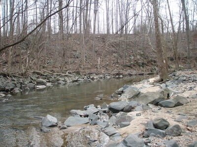
There’s a good deep cut at the sharp bend at the northern end of the red track on the map where I spent a good half-hour fishing hard. I floated any number of nymphs – different sizes, different patterns – down the deep slot with no results.
Feeling a little bit frustrated, I looked upstream and did not see anything interesting, so I hopped on the path to move quickly up to better water. It turns out that the better water is in the backyard of the house pictured below. Given the number of plastic chairs perched along the bank, I’m sure this nice, deep pool is the personal swimming pool/fishing hole for this lucky landowner. It sure must be nice to have the State stock your backyard a number of times each year.

I fished the pool from the eastern bank and still did not produce any action. As I moved farther up the bank, I noticed “posted” signs near the home and can certainly understand that you would not want people walking through your backyard as the home is only 50 feet from the river. After a glance at my watch, I realized I had to go to attend the seminars at Bass Pro Shops. I called it a day and walked quickly down the improved path on the ridge overlooking the east bank back to the car.
Little Patuxent River Trout Fishing Bottom line: This section might be better when the water level is up. However, I recommend you discover that by working up from Savage Mill rather than here at the Park. Another option is to walk downstream from the entry point to the junction of the Middle Patuxent and the Little Patuxent. As I mentioned in another post, this is a better stretch as it’s a flatter gradient and will hold more water. By starting downstream, you can exploit that water and only need to move upstream as far as the fishing is good. While you can catch some huge fish that the DNR stocks down near Savage Mill, you’ll be belly to belly with a huge number of other fishermen in less you hit that spot in the middle of the week
Getting There: The parking area is in the Savage Park that is to the west of the town of Savage, MD. From Rt 1, turn west on Gorman Road followed by a right on Foundry St. This will take you over the bridge at the Savage Mill access point. Turn left on Baltimore Street. Turn right on Fair St and follow it into the park. Drive around behind the building and you will end up in the small parking lot at the trailhead.
Walk west down the trailhead. You will see the river to your left down the steep hill. There is a fisherman’s path that leads to the river or you can skid down the slope..
Google Local Coordinates: 39.14024, -76.83013
Secrets Revealed? No. This is a very public location that is documented in the Maryland DNR stocking plan
Date Fished: 03/07/2009
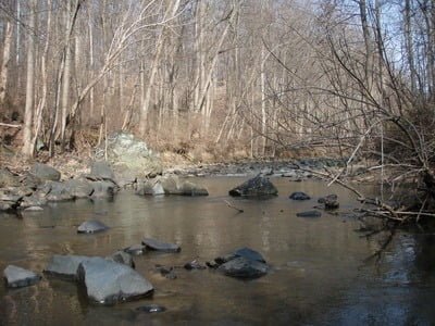
Upstream from the entry point
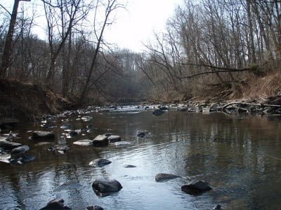
Downstream from the entry point

Wide path near the river for most of the way
One of the “better” pools
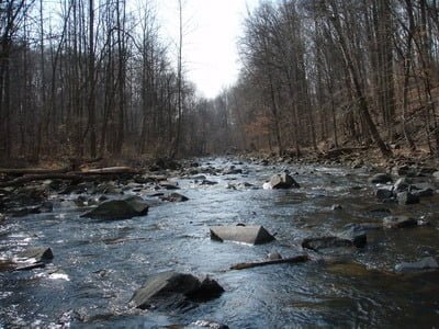
Most of the river looks like this

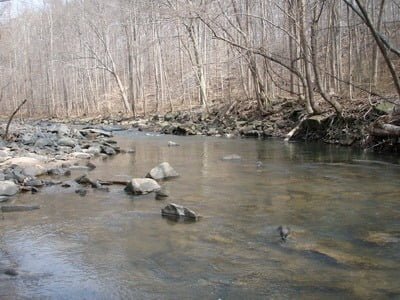
More skinny water than deep… upstream from the elbow
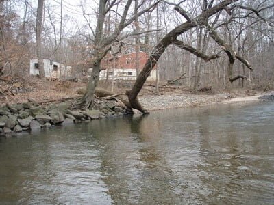
At the top, near the road, there is one big pool… in this guy’s back yard
Looking downstream from above his property – a nice bend pool, but you have to fish it from the river or the left bank. He has a posted side on the right bank.
Unless stated otherwise, this article was authored by Steve Moore