Chris and I hit the “Yawk” in late September. After being excited by an earlier trip to the Yawk up near Ohiopyle in PA, I had high expectations. There are a number of different access points to the river in MD – Friendsville, Sang Run and Hoyes Run. We hit all of these points – this report will focus on Hoyes Run.
The character of the river is very different from the stretch at Ohiopyle. The water was very low on the day we were there. This leads me to believe there are different management strategies in place. The section at Ohiopyle was very wide, reasonably deep and fast. At Hoyes Run, the river was wide and shallow with a flow that deceptively appeared to be little better than a trickle. There are numerous signs posted that caution the fisherman that the water level can change quickly based on the releases from the dam – so even on a low day, one should not be comfortable with the level. In fact, some of the web material recommends that if you see the level rising, to move quickly to the side where your car is parked to ensure you can get out.
While we clearly caught the section on a down day, certainly a wide variation of water level would do much to improve the fishing. My opinion is that you need a consistent minimum level – if the shallowness we encountered is typical, then you need to match your expectations to that situation.
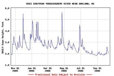
A quick view of the gage height over the last year shows that the depth was about 6 inches below normal when we were there. Looks like the average height would be around 2’6″ or so.
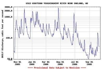
Checking the discharge, we were absolutely there on a low day. So an extra 6 inches of depth, given the width of the river, makes a staggering difference to the volume.
Ok -bottom line – not as good as it could have been, but how’d we do?
This is a nice river – it is scenic, broad, rocky, slick with a diverse population of fish. We caught plenty of smallies and a few rainbows.
The first, and important thing to note, is that we did not fish the C&R area. We fished in something called “designated trout water”, the “yellow line” on the map board at the Hoyes Run parking area. I called the fisheries service to understand what this meant and got the answer that it was water that was subject to the statewide regulations with no other restrictions. Since you can keep fish there, that may explain why we did not run into more trout.
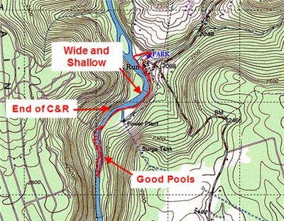
We walked up to the powerplant on the road and then hopped in the river and worked up the left bank to avoid trespassing on the power plant property. We started to fish where the terrain closed in as shown in the map. I took a reading where we entered the river and, according to my stream thermometer, the water was 62 degrees. While not as cold as I would have preferred for trout, it was in the viable range for trout water.
The first thing we noticed was that it was hard to find the pools since the water looked so low. As we worked up the river, it was easy to write off a section as “too shallow” only to discover when you got up to it that it was a nice chunk of pocket water. The optical illusion was enhanced by the width of the river – it made everything look very shallow since you were not treated to the sight of gushing water roaring over riffles. The reality is that wherever you see a wide spot – wider than a dribble – it is probably a pocket. You need to execute the appropriate “trout sneaking” approach to work that water.
The section near the power plant is wide and rocky. There are no paths on the side of the river in this section, so you are forced into the river. If the flow was higher, this could make getting up the river very tough. The wide sections compress as you move south (upstream) and the river changes to be deeper, containing wide and obvious pools that are surrounded by huge boulders.
We had a great time in the pools. The smallies were hot to grab anything silver and attacked jointed rapallas in the “brown trout” pattern with equal abandon. The top water pattern proven on the North Branch was effective here as well. Throw it, wait for the ripples to die out and then twitch. Around 30% of the time, a smallie would lunge at the lure. They hit the spinners in the first 1/3 of the retrieve – let them sink about 1/2 way down to the bottom before starting to pull them back.
We worked our way up the river until around 3 PM. Looking farther upstream, it appeared to get more craggy and tough – but the lure of nice pockets of water really exerted a pull. Given the tough going, I doubt this section of the river sees much pressure. In fact, we were there on a Saturday and only saw one other car in the parking lot and only one other fisherman on the river. He was working the C&R area north of the power plant.
The walk back to the truck was tough. Not only because we were in a hurry since we wanted to fish the Swallow Falls area of the river on this same day, but because the rocks were just nasty. You really have to be careful where you step and do need a wading staff to survive. Cleats are a given on this stretch.
Switchfisher’s Bottom Line: A keeper. A little more flow would make this even better. I’ll be back.
Getting There: “From I-68 take Exit 14A, Route 219 South. Continue about 11 miles and turn right on Sang Run Road. Proceed 0.3 miles and turn left on Hoyes Run Road. Continue about three miles to a stop sign. Turn right on Oakland-Sang Run Road” from the Deep Creek Hospitality Site. Follow that road until you cross over the small bridge pictured below and pull off in the lot.
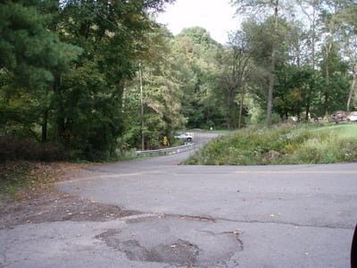
If you come in from Oakland, you could drive by the parking area for Hoyes Run if you are not alert. The parking area is right across the bridge where you see the SUV parked in this picture
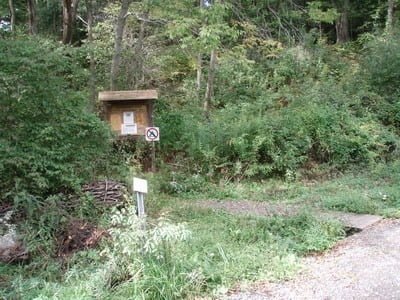
At the parking area, the trail is well marked by the sign with the regulations. Caution – plenty of poison ivy on the way to the river.
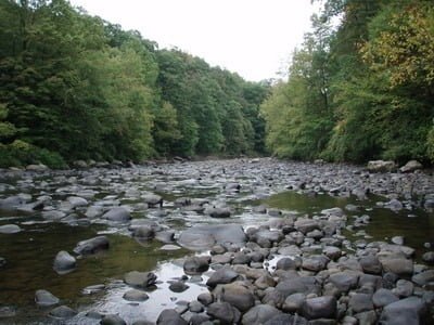
Here is the river where we started fishing south of the power plant. The pools shown are all pocket water, but you can see how it would be easy to assume that they are too shallow and should be skipped.
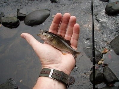
Plenty of little guys like this are anxious to jump on anything you throw
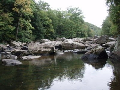
Once you work south from the power plant, the river narrows, but pools up.
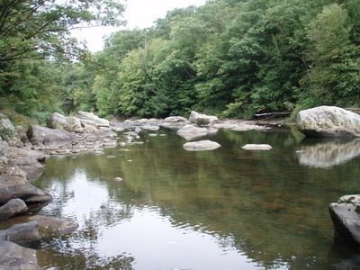
We spent several hours working a series of pools – the rocks channel your travel – it is very tough to move upstream.
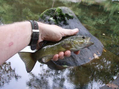
We caught plenty of smallies like this. Typical size.
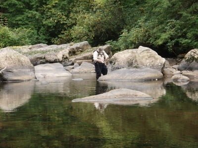
Chris working one of the pools. Note the large boulders – the river changes from the smaller rocks that will twist your ankle we saw earlier to massive boulders you have to crawl across to move upstream
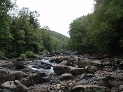
Exceptionally tough going, nice, narrow deep and fast runs that spill into pocket water. You really need cleats and a wading staff on this section!
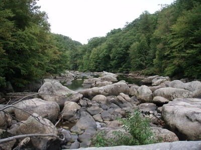
View upstream from where we turned back. This picture was taken at the top of the one to the left. Even in this one, you see a nice pool at the left center of the picture.
Unless stated otherwise, this article was authored by Steve Moore

I only own chest waders – but they were overkill in this section. In fact, given the warmth of the river, you could have wet waded just fine. I plan on ordering some thigh highs when the sale hits over the winter.
Also note that I was trying out the “redhead” version of a trout bag. I converted the pouch system normally used for hunting into hauling all my trout junk.
