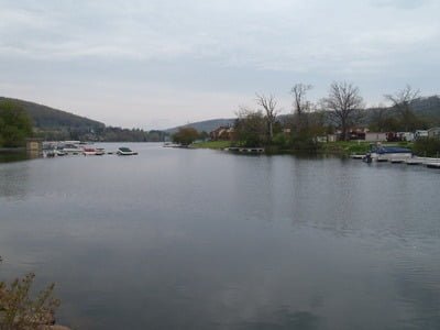
Initially constructed in the 1920s to run a hydroelectric plant, the lake is now the top vacation destination in western Maryland. According to the DNR, the lake is 13 miles long with over 69 miles of shoreline. It reaches a maximum depth of 75 feet and averages 25 feet. In addition to the trout that hold over from year to year in the cold water, it also supports a vibrant fishery consisting of large and smallmouth bass, walleye, yellow perch, and some northern pike. Most of the shoreline (the buffer strip) is owned by Maryland, although anglers must avoid boat docks and the area near the lake outlet.
State ownership of the buffer strip is emphasized via the requirement that property owners adjoining it must obtain an annual permit. Therefore, the vast majority of the shoreline is open for fishing.
Getting There: North: From I-68, take exit 4 onto MD 42/Friendsville. Turn left onto Maple Street and follow it to the start of MD 42S. Merge onto US 219 and continue south to the lake.
South: From Oakland, MD head north on US 219 to the lake.
Access Point: Too numerous to document. However, the easiest, most obvious place is the shoreline of Deep Creek Lake State Park (39.516401,-79.310224). It includes one mile of shoreline with easy access for fishing.
Secrets Revealed? No. This is a very public location that is documented in the Maryland DNR website.
Tell a friend about this article by clicking on this link


Unless stated otherwise, this article was authored by Steve Moore


