


Located in the distant northern backwoods of Maryland only a few feet from the Pennsylvania border, Friends Creek runs for approximately 2.5 miles along Friends Creek Road and is one of the most heavily stocked streams in Frederick County. The stream runs through private property and there are numerous Maryland DNR signs cautioning anglers to respect the property owners’ land to protect continued public access to the creek.
At its western end, there is a small amount of parking, adequate for four or five vehicles, next to the bridge that is approximately 300 feet north of the intersection of Sunshine Trail, Friends Creek Road and Eylers Valley Road. Access to the stream is via the fisherman’s trail that starts at the southern end of the bridge. To walk along the creek here is to fall in love with it. In general, the topography of the stream is consistently rocky, matching the stereotype of good trout water. It winds its way through a level valley that has just enough change in gradient to create dramatically different structure moving from west to east. At the western end, the stream runs fairly flat through forested farmland and transitions to a more mountain-like appearance a mile to the east. It follows the typical run, riffle, pool pattern that makes fishing a joy.
Driving east along Friends Creek Road, the road veers away from the creek with a 100-200 foot forested buffer separating the water from the road. This eventually leads to the next access at the intersection of Friends Creek Road and what appears to be a private driveway extending across an open field to reach the creek at a small bridge. This spot is easy to find since it is the first left driving east from the western bridge (39.706289,-77.418939). Parking is limited at this spot, so exercise care and find a safe place to pull completely off the road.
In the middle, the most popular section of the entire stream starts were Friends Creek Road rejoins the creek at 39.708632,-77.411294, just west of a large house and plenty of “no parking” signs speckling the landscape on either side of the road. This is the section of the creek that is most mountain-like. Here, the creek tumbles down a gentle drop that features the small plunge pools, large boulders and tight runs characteristic of an ideal mountain setting. The best fishing is to the west, upstream, since it moves away from the road and the easy access it provides.
Continuing east, the road crosses a bridge near the Friends Creek Church of God. Instead of rocks, sand and small gravel formed the streambed for brief period with creek resuming its rocky character once it charges around the bend near a cliff. There are numerous access points between the church and the bridge that marks the eastern boundary of the stocked section (39.717629,-77.392595). Once at the bridge, recognize that the water downstream is all in private property with that fact clearly stated by plenty of “no trespassing” signs hammered to the trees.
Approximate Boundary: 39.711786,-77.427657 to 39.717629,-77.392595
Getting There:From Frederick, Maryland drive north on US 15. Take the exit onto MD 550 and turn left onto Sabillasville Road. Follow this road for approximately 6 miles and turn right on Harbaugh Valley Road. After crossing across Friends Creek, turn right on Sunshine Trail. After a quarter mile driving south, Sunshine Trail forks with Friends Creek Road on the left and Eylers Valley Road on the right. Friends Creek Road continues east, paralleling the creek leading to all the access points.
Friends Creek Trout Fishing Secrets Revealed? No. This is a very public location that is documented in the Maryland DNR stocking plan.
Tell a friend about this article by clicking on this link
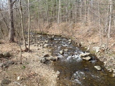
Upstream near the western access

Downstream at the western access

Upstream at the “driveway” access

Downstream at the “driveway” access

The “mountain” section

Upstream from the eastern boundary
Unless stated otherwise, this article was authored by Steve Moore