

Approximate Boundary:
· Section 1: 39.643976,-77.413452 to 39.642732,-77.406925 (4,368 feet)
· Section 2: 39.643976,-77.413452 to 39.651212,-77.435853 (1.62 miles)
· Section 3: 39.65826,-77.445302 to 39.663206,-77.449758 (2,395 feet)
· Section 4: 39.667368,-77.452977 to 39.675428,-77.458169 (3,983 feet)
Owens Creek, a mere valley away from Big Hunting Creek, is managed under remarkably different regulations. As noted above in the type of regulation, there are two major subdivisions of Owens Creek.
The entire lower section downstream from the church next to the bridge on Foxville Deerfield Road is managed as a reverse delayed harvest. Elsewhere in the State, May 31 marks the end of the delayed harvest restriction and the start of the opportunity to keep fish. The reverse is true on Owens Creek. In this stream, the Spring stocking season is “put and take,” while the remainder of the year is artificial lures, catch and return. This allows for some of the trout to hold over if the water does not become excessively warm in the hot Maryland summer and provides an extended opportunity for trout fishing when other anglers are in hot pursuit of bass.
Sadly, some landowners do not authorize angler access, which is why the lower section is fragmented into four fishable areas. This places an additional obligation on the angler to be alert for private property and to respect property rights. Besides, the DNR will not stock on private property unless the landowner offers access, so there will not be any fish to catch outside of the public areas anyway.
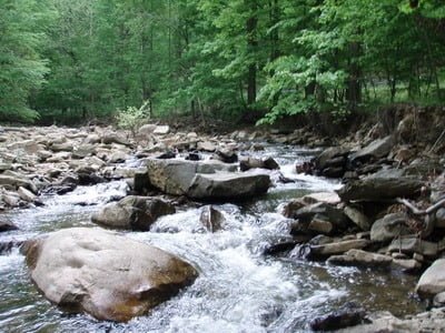
Except where it runs through the level valley just downstream of the Foxville Deerfield Road bridge, Owens Creek is a high-gradient channel stuffed into a narrow bed speckled with boulders and cobble.
Section 1
Make a right turn from US 15 to drive all the way to the covered bridge and throw an eyeball on the small stream to the right of the road. It all looks good. The water dribbles downstream across a solid rocky bottom with plenty of shade thrown by the tall trees that line both sides of the bank. Below US 15, there are at least four different turnoffs with the largest one being at the covered bridge itself. Although the stream runs through Roddy Road Park, the bank at the northern edge of the park is steep and inaccessible. Ignore the park and stick with the turnoffs on Roddy Creek Road. With all of the private property issues encountered farther upstream, it is reassuring to see the numerous DNR “stocked water” signs confirming both public use and the promise of stocked trout. In addition to fishing at the covered bridge, the other good location is at the deep pool on the other side of the metal barrier, which starts immediately after the intersection of Roddy Creek Road and Albert Staub Road. Park at the turnoff located at 39.639687,-77.398851, and walk upstream to fish. Except for those two spots, anglers must walk the stream to find the deeper sections that hold fish.
Above US 15, after dodging around a small shopping complex, the creek returns to parallel Franklinville Road. The public section continues to be well-marked even though it is set back farther from the road. The dense forest protects the creek as it flows across the same rocky bottom seen farther downstream. The transition back from public use to private property is clearly marked by the presence of houses at the northern end.
Section 2
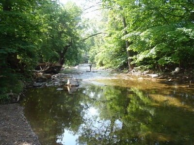
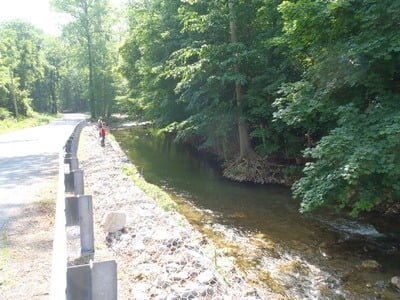
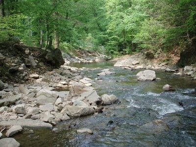
Although the stream was trout friendly in the first section, the best part of Owens Creek is the stretch below Eylers Valley Flint Road. Not surprisingly, this section sees the most pressure on the entire creek. The stream runs away from the distractions of private property through a deep, forested valley framed by railroad tracks. It is easier for the stream to cut deep pools and good runs as it winds its way down the high gradient to continue to parallel the road. The only good place to park is just east of the railroad overpass. This also happens to be adjacent to the best pool in this section. While there are other places to fish for those who are willing to walk and look for holes, this particular spot experiences the heavy us pressure. Upstream underneath the railroad crossing, there is another narrow and deep slot that holds fish.
The other primary access point is that the extreme northern boundary (39.651414,-77.435801). If you park there, fish downstream since upstream is posted. Fishing downstream from this spot is productive given the fractured nature of the creek. As it runs down the hill, the boulders create numerous holding positions – both stocked and wild. Look for the bends where the downstream rush of water carved out deep cuts.
Section 3
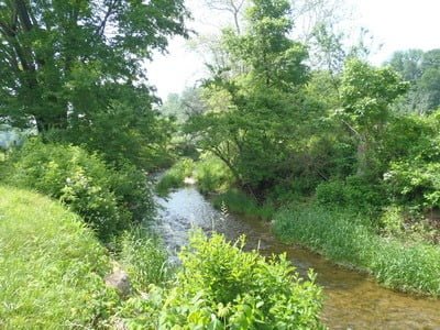
In fact, the next section north of Eylers Valley Flint Road is hardly worth fishing as a result of the obstacle presented by the dim trail running down the steep hill to eventually join the stream. I have no idea if or how the DNR actually stocks this small stretch. The one time I fished it, I only caught fallfish. Therefore, do not bother to fish this section. While a scenic view of a small creek shaded by a full canopy of dense trees greets you as you break out of the brush onto the water, that water is mostly a stagnant mess. This section is in a gentle, level stretch between the surrounding steep mountains and that causes the water to become shallow as it spreads out with a few scarce deep spots hiding near rocks and cuts where the creek changes course. There are only two access points, both on the west side of the road.
Section 4
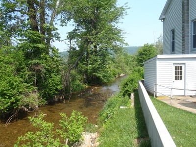
In this, the last section of the lower Owens Creek, the stream winds lazily through open fields. It is remarkably slim, being only 10 to 15 feet wide as the stream crosses the upper boundary of the stocked section at the bridge on Foxville Deerfield Road. On the north side of the bridge, there is a deep pool that is 15 to 20 feet wide fed by cool water from the thickly shaded area immediately upstream. While there are two turnoffs south of the village of Lantz, the major access point is that the bridge. The rocky bottom becomes mixed with more sand as the velocity of the stream slows through the flat valley.
Getting There: Head north from Frederick MD on US 15. Once past Thurmont, turn right onto Roddy Creek Road. Follow it to the covered bridge that marks southernmost public section of Owens Creek.
All of the other sections are west. Instead of turning right on Roddy Creek Road, turn left on N Franklinville Road, followed by another left onto Franklinville Road and follow it to the “T” intersection on Kelbaugh Road. Turn left and then right on Sabillasville Road/N Church Street.
Stay on Sabillasville Road until it reaches a fork at the railroad tracks with Foxville Deerfield Road. Follow Foxville Deerfield road to the bridge crossing that marks the upper end of the stocked section.
Access Point:
Section 1:
· Below intersection of Albert Staub and Roddy Creek Roads (39.639687,-77.398851)
· Covered Bridge at Roddy Creek and Roddy Road (39.641026,-77.393812)
· At least 4 different turnoffs along Franklinville Road north of US 15
Section 2:
· Just east of the railroad overpass on Sabillasville Road (39.649078,-77.426287)
· Just east of the first residential property on the right (39.651414,-77.435801)
Section 3:
· Turnoffs on the west side of the road at 39.66111,-77.44745 and 39.66270,-77.44839
Section 4:
· At the bridge on Foxville Deerfield Road (39.675239,-77.457903)
Secrets Revealed? No. This is a very public location that is documented in the Maryland DNR stocking plan and the Guide to Maryland Trout Fishing
Tell a friend about this article by clicking on this link
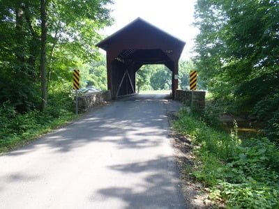
Southern end – start of stocked water
Southern end

Near US 15
First hole south of US 15
Near the railroad crossing – at the big turnout
Downstream from the rail crossing
Church section at the upper end
Downstream into the field at the upper end
Unless stated otherwise, this article was authored by Steve Moore