


Approximate Boundary: 39.599406,-76.626424 to 39.619243,-76.706557 (7.32 miles)
DNR Guidance: Mainstem from Prettyboy Reservoir Dam downstream to Blue Mount Road
The Prettyboy Reservoir section of the Gunpowder River is one of the jewels of Maryland. It is one of the locations that Trout Unlimited rates as one of the top 100 streams in America. As such, you will find that hundreds of anglers want to polish it. The DNR does not stock the catch and release area and relies on the excellent habitat to sustain the wild trout fishery. As a point of interest, the entire Gunpowder Falls River, mostly protected by the Gunpowder Falls State Park, all the way down to the Loch Raven Reservoir supports wild trout, with the best holdover closer to Prettyboy Reservoir.
The farther downstream you move from Prettyboy Dam, the more the pressure drops off. Although the section from Falls Road up to the dam is the most scenic from a trout fishing perspective, there will be an angler standing in the stream every 50 yards or less on weekends. Every pool will be occupied, and the trout will huddle, trembling in fear, under any available cover. That said, the Falls Road section is ideal to fish during the week when the trout have had the opportunity to settle down. During periods of low pressure, you can wander unconstrained and fish the spectacular pools that dot every twist and turn of this glorious river.
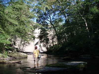
Starting at the dam and working downstream. The river runs tight and narrow through a soaring canyon that towers 300 feet above the streambed. The shoreline is overloaded with vegetation, with fallen trees connecting both sides, creating confused structure masses. It seems as if the river bottom needed to match that challenge and composed itself using a jumble of boulders and rocks of various sizes that were custom-made to trip the unwary angler. Wading can be treacherous if you step carelessly. The trail from either parking lot moving upstream is tight and narrow as it winds up and down the precipitous hillsides. With a thick curtain of vegetation separating the trail from the river, you may surprise other anglers when poking your head out to check out the stream. Given that, approach quietly so as not to destroy someone else’s fishing experience. By the time the river reaches the Falls Road bridge crossing, it has widened out to run across a rocky bottom with a significant amount of gravel. Shallow water comes with an increase in width.
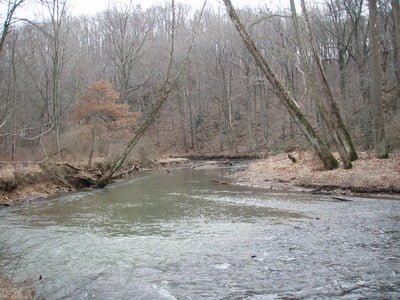
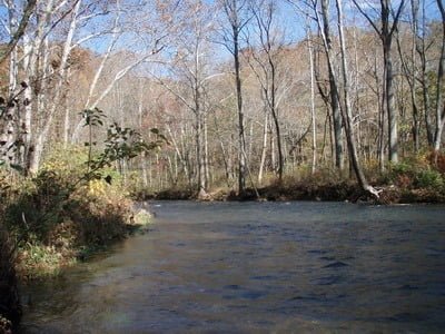
Downstream of Falls Road, the river takes a break as it leaves the tight canyons and enters a slightly wider valley upstream of the Masemore bridge. At this point, the tortured twists and turns disappear, and the banks become more normal for Maryland. Once upstream of the bridge crossing, the trail drops down to the river where the bank merges gradually into the water itself. There are no large boulders, just rocks and gravel. Tall trees stretch to the sky on either side and provide plenty of shade. Fishing here is a matter of finding the deep cuts and the undercut banks. The downstream perspective is the same. Some mud begins to appear on the sides where the river deposited silt as it loses velocity, having dropped over 100 feet in elevation from the base of the dam.
By the time the river reaches Big Falls Road, there is no significant velocity as the river winds slowly underneath the tight canopy of overreaching trees and bushes. The river narrows to 20 to 30 feet wide and has dug its way deep into the mud and sand that create the banks. In fact, the river is a gash that requires picking your way carefully to reach the water’s edge. The farther upstream you go, the less of a challenge this becomes. The amount of silt should not discourage you from fishing. Random, capricious storms and floods treated trees like matchsticks, throwing them across the river to create huge wood piles that strain the water as it heads farther south. The trout are here, it just takes some work to pull them out. To sum up this section, it has deep, wide pools punctuated by trees and bushes with a few scattered rocks poking above the level of the water to provide interest and character. Between the pools, the river shallows, so use polarized glasses to understand where your lure is landing and whether any trout are nearby.
Blue Mount Road is the downstream boundary of the catch and release section. At this point, there is no defined trail on either side of the bank. Enter the river using the path next to the bridge and fish upstream. There are deep channels running over the gravel bottom that has some silt with undercut banks. Don’t be surprised if kayakers or canoeists drift through your fishing hole and note that more tubers than comfortable use the Blue Mount Road access to begin their float downstream to Monkton. The river downstream from Blue Mount Road is designated as a wild trout water with the two fish per day limit. Frankly, it is not worth fishing. Between Blue Mount and Monkton, the river runs shallow with only a few gradient breaks to create interest. There are some deep pools underneath the undercut banks on the southern side, but not enough to make it worth the hike.
Getting There:
Points East of I-83: Take exit 27 for MD 137/Mt Carmel Road and head east.
- For Blue Mount Road, turn right on York Road. Turn left on Monkton Road. Turn left on Blue Mount Road at the fork.
- For Big Falls Road, turn right on York Road. Turn left on Monkton Road. Turn left on Big Falls Road at the fork.
- For York Road, turn left on York Road.
- For Bunker Hill Road, turn left on York Road. Turn left on Bunker Hill Road.
Points West of I-83: Take exit 27 for MD 137/Mt Carmel Road and head west.
- For Masemore Road, turn right onto Masemore Road.
- For Falls Road, turn right on Evna Road. Turn right onto Falls Road.
Access Point:
- Bridge crossing at Blue Mount Road (39.599422,-76.626293)
- Bridge crossing at Big Falls Road (39.60941,-76.635331)
- Bridge crossing at York Road (39.61401,-76.659141)
- Dead end at Bunker Hill Road (39.612032,-76.672759)
- Bridge crossing at Masemore Road (39.611276,-76.682775)
- Parking lot 1 along Falls Road (39.61467,-76.69640)
- Parking lot 2 along Falls Road west of the bridge (39.61751,-76.69292)
Secrets Revealed? No. This is a very public location that is documented in the following places:
Maryland DNR
Guide to Maryland Trout Fishing
Mid-Atlantic Budget Angler
Tell a friend about this article by clicking on this link
Blue Mount Road Section
Masemore upstream

Prettyboy
Below the dam
Unless stated otherwise, this article was authored by Steve Moore