


Approximate Boundary: 39.673806,-78.724451 to 39.722808,-78.688231 (4.86 miles)
Although the stocked section extends down to I-68, the first possible access point is not until Mason Road begins to run parallel to the creek approximately 1,500 feet after it turns north away from the Interstate (39.67677,-78.72042). Even then, the road runs high above the creek with thick brush and trees blocking access to all but the most ardent bushwhacking angler. Of course, one can debate whether fish stocked upstream would migrate into this lightly pressured section and if so, then the bushwhacking becomes worthwhile. However, the road begins to run down the side of the ridgeline to rejoin the stream at 39.68029-78.71683, where there is severely restricted roadside parking. At that point, you get your first good look at the water. The creek runs 20 to 30 feet wide across a freestone bottom that is a mix of small rocks interspersed with sand. Once the road leaves this spot, it veers away from the creek for the next mile, not offering access until the intersection with Old Mt Pleasant Road.
At that intersection, the creek hugs the road for the next 1,500 feet, with several opportunities to park on the shoulder. Since the property on the downstream side of the bridge is posted, focus your fishing upstream. At this point, the streambed is a mixture of small boulders and rocks spread across a bed approximately 30 to 40 feet wide. The water runs shallow, so fish the deeper channels and holes where you can find them. The right-hand bank takes a steep pitch upward as the road leaves the straight run to move around the corner to the left. There’s a good deep pool sheltered by a tree and the reinforced rock bank supporting the road. The creek drops down a short gradient break, gathers steam, and compresses as it turns the corner into the tree. The packed, beaten trail to the creek’s edge proves that this is a popular place.
Continue north towards Pennsylvania and stop at Ferguson Lane. There is good parking on both sides of the bridge, with the fisherman’s trail leading to the creek from the western side. As it moves under the bridge, the water deepens, and the creek broadens, becoming almost 50 feet wide with a nice set of riffles and a fallen tree structure at the upstream bend.
After having to park on the side of the road at the southern access points, you will be relieved to discover the first formal parking area adjacent to the bridge where the creek runs under Smouses Mill Road. Gentle open fields provide the western boundary while thick brush protects the upstream eastern side. The upstream west bank is posted, so fish up the eastern side. Use the lightly traveled fisherman’s trail to negotiate through the thick vegetation to reach the stream. Sadly, the trail peters out close to the bend. Downstream, fishing is easier since the bank is open with streamside vegetation, offering a challenge that can be overcome by wading.
Even though the stocked section extends up to the Pennsylvania border, Smouses Mill is where you should end your day since the next access point is at the Mason Road bridge crossing on the Pennsylvania side of the border. There is no place to park and no DNR signage indicating that they actually stocked this far north or that you have permission to cross private property. Given that the bridge is actually in Pennsylvania, I doubt the DNR inserts fish in Pennsylvania water even though Maryland is 50 feet downstream. Besides, if stopped by conservation police officer at that bridge, you would be asked for a Pennsylvania license.
Evitts Creek is the fifth most heavily stocked stream in the State.
Getting There: From I-68, take exit 46 onto MD 807/Naves Crossroads NE. Turn north at the bottom of the ramp and follow Naves Crossroads until it merges with Mason Road. Mason parallels Evitts Creek.
Access Point:
· Various turnouts along Mason Road (39.67677,-78.72042, 39.68029,-78.71683, 39.698976,-78.702087)
· Mason Road and Old Mt Pleasant Road NE (39.696178,-78.702934)
· Mason Road and Ferguson Lane NE (39.705322,-78.698079,
· Smouses Mill Road NE bridge (39.709913,-78.696622)
Secrets Revealed? No. This is a very public location that is documented in the Maryland DNR stocking plan.
Tell a friend about this article by clicking on this link
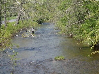
Mason Road and Old Mt Pleasant Road upstream

Embankment

Smouses Mill Road upstream
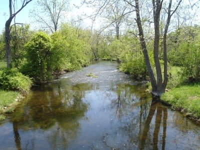
Smouses Mill Road downstream
Unless stated otherwise, this article was authored by Steve Moore