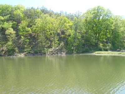
The ponds occupy the lion’s share of the 6-acre Evitts Creek Ponds Fish Management Area that sits to the west of Cumberland. Evitts Creek, stocked above I-68, creates the northern border of the three separate ponds that make up the fishing complex and provides a constant stream of cool water into the ponds.
A manicured path, punctuated by a few scattered picnic tables, runs along the northern boundary of all three ponds.
The westernmost pond is the only one approachable from the south as a result of the steep cliff that forms the southern boundary of the first two. The ponds are shallow along the accessible edges with a dark green tint denoting deeper water running consistently along the cliff. Cold water from the creek feeds in at the eastern terminus and fish huddle near the output pipe, searching for relief from the hotter water at the center of the pond.
The banks slope at a moderate pitch and do not present a challenge to movement from the path to the water’s edge. Likewise, the bottom of the lake extends away from the shoreline at a gentle angle that allows for the rapid growth of underwater vegetation. The middle lake matches the first and the only advantage of the western lake is that there is more shade along the southern and western border, providing a welcome relief to anglers on a hot day. On a clear, sunny day, you can see the larger fish cruising the perimeter of the shallow shelf where it breaks into the deep water.
Directions:
From I-68, take exit 46 for Naves Cross Road. Turn south at the bottom of the ramp, followed by another turn to the south to MD 807/Christie Road. Follow Christie Road to the ponds (on the right).
Access Point: Parking lot on the south side of Christie Road NE (39.662298,-78.717075)
Secrets Revealed? No. This is a very public location that is documented on the Maryland DNR website.
Tell a friend about this article by clicking on this link


Unless stated otherwise, this article was authored by Steve Moore


