


Fully enclosed within the 46,000-acre Green Ridge State Forest, Fifteen Mile Creek offers plenty of access and dramatic scenery. For those who want to turn their fishing trip into a weekend or longer, the state forest offers 100 designated primitive campsites with permits from the Green Ridge State Forest headquarters. According to the DNR, campsites 24-49 and 100, as well as group sites 1 and 2, are adjacent to the stocked fishing area.
It starts in the north as a low-gradient stream running through a level valley and, a short distance below I-68 transitions into a rapidly flowing river running through a narrow canyon.
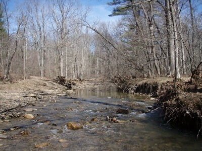
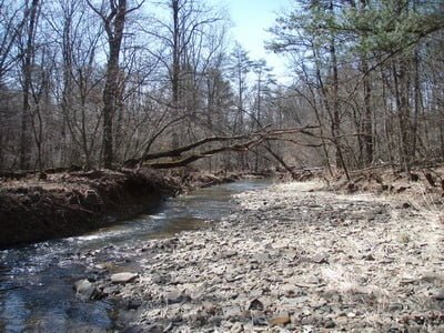
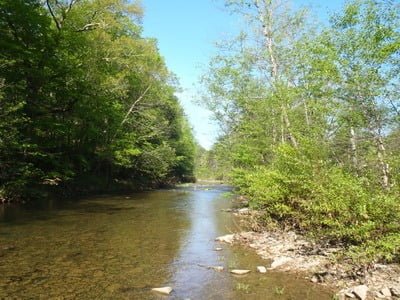
The section above I-68 is the easiest to fish. The road runs within feet of the creek, and the numerous turnouts make access trouble-free. The banks are low, and the vegetation is light during the Spring stocking season. The creek runs 15 to 20 feet wide, mostly shallow, with deep pools at the bends, or in a few places, it narrows and gouges a channel in the bottom. Small rocks and cobbles dominate the subsurface structure. Fishing from the bank is uncomplicated, and the small rocks do not hinder those who want to wade. Most of the action occurs at the multiple bridge crossings where construction creates deeper holes and easy stocking access. In the far northern portion of the stocked area, the water in the creek is minimal. The best-looking water is available much farther south after the numerous tributaries have had the opportunity to add volume to the flow. However, that does not discourage the insertion of the stocked fish in this stretch.
Below I-68, the river briefly changes character, with sand predominating and the water becoming even shallower. There continue to be plenty of turnoffs and, during the stocking season, most of these will be heavily populated with anglers. Even though the “stocked trout water” line on the map extends the entire distance between I-68 and the town of Little Orleans miles downstream, “posted” signs predominate once you turn left onto Dug Hill Road to rejoin the creek. Beyond the fact that the property is posted, the topography prevents access. Once the road turns to the west, away from the stream, it charges up a steep mountainside and runs along a ridge line almost 1,000 feet above the stream. Therefore, do not drive farther than the last easy turnout on Fifteen Mile Creek Road.
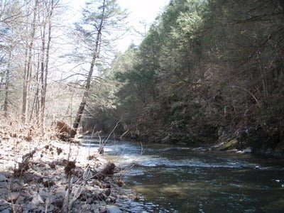
Continuing south to access the Mountain Run location, bump over the rutted dirt road from a steep ridge line to a broad parking lot adjacent to the river. Unless the road has been graded, I recommend using a high-clearance vehicle. Upstream from this location, Fifteen Mile Creek runs through a narrow valley offering dramatic scenery but no trout. The stocking truck can’t unload above the intersection with the river. While some fish will run upstream, most trout will be in the pool adjacent to the parking lot and downstream.
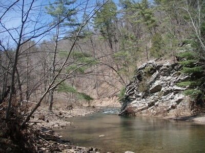
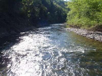
The Yonkers Bottom Road access location is also at the end of a dirt road but does not require a high clearance vehicle to negotiate. The road dead ends at a large turnout adjacent to several nice campsites. Fifteen Mile Creek runs in a loop around the bottom of the parking area and a short walk through the gated path puts you on the creek. It runs clean and clear, about 1 foot deep, across a rock covered bottom at normal water levels. The deep channel is adjacent to the southern bank and in the turns. The best approach is to move south from the parking lot and begin fishing at the steep rock cliff. You will have to bushwhack through some dense underbrush on the southern shore to move farther downstream, so be prepared to wade. The creek is very “trouty” looking as a result of the quick drop in elevation that creates fast water with pools below each line of rocks.
The final access point is at the New Orleans bridge crossing. There is a wide turnout on the south side of the bridge with parking for six or seven vehicles. At the bridge itself, an island divides the creek with the best access being on the left-hand side. The creek remains true to its rocky character at the southern end with the water is running clean and clear. The thick vegetation on each bank forces you to wade into the slow-moving stream to fish upstream into the stocked section.
Access Point:
· Numerous turnouts along 15 Mile Creek Road near I-68 (examples: 39.706170, -78.451750, 39.669654,-78.459259, 39.67849,-78.457435, 39.68664,-78.454614)
· Mountain Road intersection with the creek (39.656226,-78.396599)
· Southern end of Yonkers Bottom Road (39.639174,-78.389822)
· Intersection of Appel Road and Orleans Road SE (39.628005,-78.389449)
Upper Section
Upper Section
Middle off Mountain Run
Middle – not steep hills
Yonkers Bottom Road
Yonkers Bottom Road
Unless stated otherwise, this article was authored by Steve Moore