In his book Flyfisher’s Guide to Virginia, Hart highly praises the North Anna River. However, he looks at it from the perspective of a canoe trip rather than a wading attack. Not wanting to deal with the hassle of shuttling a canoe, I looked for an alternative that would allow me to wade the river. Hart did not disclose any good wading access sites, and, in fact, he clearly states that you cannot wade from where he recommends you put the canoe. Hart’s put-in is on private property where the landowner is kind enough to allow canoeists access for the donation of a dollar. The sign, at this point, specifically restricts access only to canoeists and not to fishermen.
A detailed map recon of the lower end of the trip Hart recommends reveals a hidden treasure. The North Anna Battlefield Park borders the river about 3/4 of a mile upstream of the takeout point. Since Hart says that the last mile of the trip is a waste of time for fishing based on poor smallmouth habitat, access through the park seemed like a perfect solution to get to the river.
Lon and I pulled into the park at about 8 AM Friday morning to test this theory. The parking lot has a detailed map oriented at the civil war activities but clearly indicates how to get to the river. All you need to do is follow the signs for Marker 9. We followed the well-marked and well-maintained trail down to marker 9, which is on an elevated deck overlooking the river at the top of a steep hill. Shortly before you reach the historical marker, there is a well-beaten trail to your right that you can skid down to get to the water. Caution — this is a very steep hill and requires that you be in reasonable shape to get back out at the end of the day.
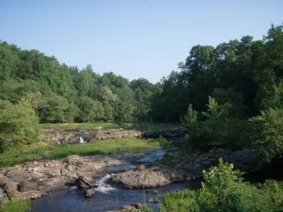
Relying on Hart’s book, he indicated that the best smallie fishing starts above the fall line rapids. The water at the entry point is narrow and shallow. The river here is about 30 feet wide and runs inches deep. While Lon worked a pool, he saw a bit downstream of the entry point; I started to slog upstream in search of better water. About a quarter mile above the entry point, I rounded a bend and saw a broad “lake” that led up to what clearly were the fall line rapids (point 003 on the map above).
The rapids are a staircase of cascading water that instantly raises the elevation of the river by 20 feet. At the base of the rapids, there is a beach area to the right which, from looking at the trash, has been used as a campsite by any number of canoeists. There was a tent pitched on the beach and the faint odor of a cooking fire in the air as I quietly walked by. I climbed up the rapids and noted a well-developed dirt road to the right that led to this spot. If I come back here, I’ll have to take the time to do a recon to see if there is public access on this road that would allow me to drive directly to the fall line rapids and save the time spent walking to this point from the battlefield Lon and I began fishing in earnest above the rapids.
There is another deep lake that ranges from wadable to drownable immediately above the rapids. The water moves fast in this broad, 70-foot-wide stretch. I began to work my way up the right-hand bank, targeting the fast cuts and the overhanging trees next to the bank. It was not long before I began to pick up smallies and, of course, any number of bluegills. By this time, Lon had caught up with me, and he fished the narrow, fast stretch that led to the main run through the rapids. Like me, he began to catch fish immediately. I was surprised at this action so close to the campsite but was encouraged by it at the same time.

Over the next several hours, we finished our way upstream and had a great time. We never ran into a section that was not negotiable on foot. I concur with Hart’s assessment that this is a canoe trip you should take in the spring when there is plenty of water in the river. The numerous shallow stretches we encountered would be a nightmare for a canoe. You would spend more time dragging your way downstream than you would floating. The North Anna River never gets wide enough to where you feel like you are unable to fish the entire river. In a typical stretch, the average width of the river is between 30 and 40 feet. The average depth is about 2 feet with the scattered deeper holes that hold the larger fish.
The west bank of the river features “posted” signs throughout the entire stretch once you leave the battlefield. The east bank is not posted but you won’t walk on that land either as there is no trail on either side of the river. Once you are in the water, you will stay in the water as you fish your way upstream. The river itself is mostly a rocky bottom with infrequent sandy stretches. Since the sandy bottom usually is not good smallmouth habitat, I was happy to see them minimized. You can move upstream faster if you skip those sections and focus only where you can see (or trip over) rocks or grassy vegetation.
While we did not catch any trophy fish, we did see some of them huddled with their buddies laughing at our attempts to coax them to bite. The typical smallie I caught was between 10 and 12 inches. The bluegills are huge in this river and many of them were 7 to 8 inches long.
North Anna River Fishing Bottom line: I like the North Anna River. I had the sense that it is lightly fished as a result of the access challenge. That dirt road I saw is tempting and I need to figure out whether it can be used to extend the fishing day by being able to start at the rapids. While I was using my bass rig or poppers, Lon stuck with traditional flies and used a bitch creek nymph with great success.
Getting There: From I95, take exit 104 to VA 207 West. Turn left onto Route 1 and follow it for about 5 miles. Turn right on Verdon Road and look for the entrance to the park on your right. You will drive down a dirt road that looks like it goes through somebody’s back yard, but it is the entrance to the park. Follow it across a wide dirt road where there is construction (July 08) and continue to the parking lot. The trailhead is behind the large sign at the southwest corner of the parking lot.
Google Local Coordinates: 37.885608, -77.497044
Secrets Revealed? No. This is a public location that is documented in the Flyfisher’s Guide to Virginia

Upstream from entry point

Downstream from entry point

Tragic trash at the fall line rapids

Looking upstream over the fall line rapids

The “lake” above the rapids. Lon working the slot.

Typical North Anna Smallie

Typical “non-lake” stretch

Plenty of good spots to take a break
Unless stated otherwise, this article was authored by Steve Moore


