After the aborted search for fish on Dragon Run, Lon and I decided to continue to head west and see what the Mattaponi had to offer. According to the Flyfisher’s Guide to Virginia, the Mattaponi above the town of Aylett has plenty of sunfish, bass and walleye. No mention of smallmouth, but bass is bass and we were anxious to tie into anything after the long drive and futile recon of Dragon Run earlier in the morning. It was about a 45-minute drive from Dragon Run to Aylett.
As we came into the town from the east, we hung a left after the bridge and followed the signs to the well-marked access point. We pulled into it, and I was impressed by the size of the parking lot and the improvements. In addition to a nice boat launch, there were two docks built into the side of the river. My excitement disappeared as I walked closer to the river and realized there would be no wading here. This is canoe country! At Aylett, the water was running deep and fast. A local drove up, and I asked him if the water got shallower farther upstream, and he shook his head no. Realizing that Aylett was not the solution to getting onto the water, Lon and I decided to continue up Rt 600 to see if it was any better at the other access points. We knew we already had the answer from the local, but we needed to see for ourselves.
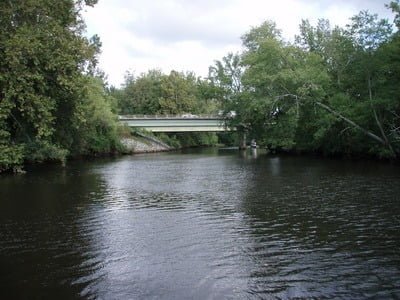
We drove to the Mundy Bridge and the Reedy Mill access points, and both were essentially identical. They had small parking areas with nondescript canoe access to the river. The river was tight, with densely packed trees and a narrow channel. I doubt the river was over 30 feet wide in either of these places. With a longing gaze in either direction, we concluded that this day would be a waste unless we could find someplace to fish. We huddled over the Virginia Gazetteer as we made plans to recover.
Mattaponi River Fishing Bottom line: You need a boat to get in the water at the Aylett access. Farther upstream, access is restricted to canoes or kayaks. We did not see any indication from the bridge that the Mattaponi offered anything close to classic smallmouth water – everything was flat, close and uninviting. Granted, smallmouth was not a species listed in the guide, but you do want some kind of the scenery when you’re on the water. I could see where this would be good largemouth bass habitat as the river in the upstream sections did not appear to be very fast-moving while it was deep.
I might come back here with the canoe someday. The challenge is whether the long drive to reach the Aylett access point would be worth it given gas prices. There is better water closer to Northern Virginia than this.
Getting There: From I95, get on Rt 30 East. Follow it to Rt 360 and turn left (east) towards Aylett. Turn right on W. River Road right before the bridge and follow the signs to the launch.
To get to Mundy Bridge, go north on W River Road, Turn right on Dorrell Road and follow it to the river.
Continue on W. River Road (it turns into Frog Level Road) and turn right on Mt. Vernon Church Road. Go past the Reedy Millpond and turn right on Reedy Mill Road to go over the bridge. The access is on the pond side of the bridge.
Google Local Coordinates: 37.785626,-77.102094
Secrets Revealed? No. This is a very public location that is documented on Mattaponi page of the Virginia VDGIF and in the Flyfisher’s Guide to Virginia

Looking upstream from the Aylett Access

Downstream from Aylett

Looking downstream from Mundy’s bridge

Upstream from Mundy’s bridge

Looking downstream from Reedy Mill

Looking upstream from Reedy Mill
Unless stated otherwise, this article was authored by Steve Moore


