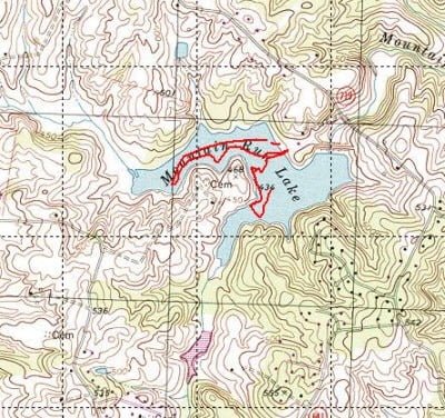
When the latest rankings on bass water in Northern Virginia came out, and Mountain Run outside of Culpeper was rated as the third-best lake in the area, I knew I had to visit it… And soon. But wait! The VDGIF site indicated that to fish on this lake, you need a permit, which the Office of the Treasurer issues during business hours in Culpeper. I instantly recognized that the need for a permit became a filter that limits the pressure on the lake. Forcing everyone except the locals to make the long trek to Culpeper to buy a permit during business hours is a significant hurdle. I bided my time and, on my way back from fishing the Rivanna in Charlottesville, I stopped in Culpeper to acquire this important document.
The address on the VDGIF website is pretty good — it gets you right to the office. Walk through the doors and hang a right to enter the small room where any of the three clerks are happy to sell permits. I waited my turn and asked for a permit to fish. While it was inexpensive at $5, each person who is going to fish needs to have their own permit. Happy that I was ready to go, I left the office and made plans to visit the lake the following Saturday. On schedule, we loaded the Basscanoe on the truck and made the hike out to Mountain Run.
As we pulled into the lake, I noticed a large sign to the right of the entrance that listed the regulations for this body of water. In case there was a slot, I stopped to read them. The thing that instantly jumped out was that it in addition to a fishing permit, you need to have a boating permit as well. I can’t tell you how many four-letter words ran through my mind when I saw that. Why didn’t the clerk ask me if I also wanted a boating permit? Why didn’t the VDGIF site indicate that besides being a fishing permit, you also need a boating permit? I sent VDGIF an email and much to their credit, they updated their site to indicate you need both. With a longing glance at the small, picture-perfect lake sparkling in the distance, I turned the truck around and left. There was to be no fishing here on this day. All my fishing permits gave me was the right to fish from the shore.
A few weeks later, on a Friday, Art and I fished on the Rappahannock near the disabled hunters’ access point. At the conclusion of our day there, we made the quick hop over to Culpeper so I could pick up the requisite boating permit. With all permits finally in hand, I was finally ready to go back.
Two Saturdays later, we reloaded the Basscanoe and headed back to Culpeper with a wary eye on some dark clouds that were building to the south. Usually, when we go out in the canoe, it’s only for a few hours anyway, so I hoped to beat whatever thunderstorms might be in store. We launched the canoe and started to work up the north side of the lake. This is a lake that is full of structure. Once you get away from the launch point, some thick bushes and trees crowd the edge of the lake, throwing a consistent band of shade to attract hot fish.
I had the depth finder running and was surprised to see how shallow the water was along the track I followed. For most of the northern stretch, the water ranged from 2 to 5 feet deep. The bottom, where I could see it, looked fairly barren with sand and clay. We worked down the shoreline and it started to spit some rain. No thunder; maybe no problem? We decided to see if this would only be a passing sprinkle and continues to flip lures at the likely holding areas.
Bad call. A few minutes later the rain started to hammer down. I put the trolling motor into high gear and made a beeline back to the truck. We decided to wait it out since we were already here anyway. Thankfully, it was only a passing shower, and we were back on the lake in about 15 minutes. This time, as we motored out, I noticed that the water right in front of the boat launch was deeper – running up to 15 feet. In addition, I was picking up plenty of fish marks on the depth finder in this area. It looked as if this “deeper” area ran right up to the bank on the peninsula across from the boat ramp, so we worked that area. Moving south along that far bank, we were picking up plenty of bluegill but no bass. As we rounded the bank, the sky started to rumble again. Being an optimist, I told the Basswife “maybe it will pass to the north of us” as we continued to fish the bend. The depth of the water here seemed to be consistent with the depth in front of the boat launch and not as shallow as the northern track.

My explorations were cut short by a burst of rain and the realization that the weather was going to conspire against us on this day – zeroing out the magnificent effort I had made to secure all the required permits. I headed back to the shore and pulled the canoe onto the bank just as the sky opened up. I packed up as quickly as I could, and we departed the scene.
Mountain Run Lake Fishing Bottom line: This is a scenic lake. I have a good feeling about it and need to come back. The short 45 minutes of fishing time we spent was only enough to scratch the surface.
The one thing I think this lake has over the Occoquan and some of the other reservoirs in Northern Virginia area like Motts Run is that it is not 30 to 40 feet deep. I don’t know about you, but I have a hard time catching fish in deep water. I’m just not good at it. Based on this short recon, it looks like Mountain Run is a lake that has a manageable depth that will allow me to get my lures in front of the fish.
Given the filter of the fishing and boating permits, I do not believe this lake is heavily pressured. While we did see a number of people fishing from the shore on both of our visits, even they are restricted to a small area as the shoreline closes out into private property a short distance from the boat launch. We were the only boat on the water the day we fished and I only saw one other boat out on the day we tried to fish.
I’m going to give this lake a green rating on the promise of a better day on my next trip.
Getting there: Mapquest yourself to Culpeper. Head south from Culpeper on Route 29 and turn right onto Mountain Run Lake road. About a mile down the road, you will see the entrance to the park on your left. Take the second entrance and go to the end. That is where the boat launch is.
Google Local Coordinates: 38.479583, -78.069643
Secrets revealed? No. Mountain run is fully documented on the VDGIF website.

Looking back towards the boat launch

The pennisula is on the left. Shot taken looking northwest

The good structure continues around the rim of the lake.
Sadly… no fish pictures. We did not catch any bass.
Unless stated otherwise, this article was authored by Steve Moore


